
User Guide


GPS NAVIGATION
5-19190-00494-00 Rev. B
Garmin G1000 Pilot’s Guide for the Cessna Citation Mustang
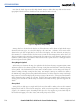
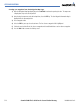
Airway Line Style
The route of low altitude airways are drawn in gray (the same shade used for roads). Note that VFR
sectional charts use light blue for low altitude airways – but on the G1000, that color has the potential to
be confused with airspace boundaries.
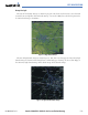
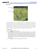
Figure 5-12 High Altitude Airways
The route of high altitude airways are drawn in green. This color is used on Jeppesen charts where high
altitude airways are shown on low altitude charts. When both types of airways are selected for display at
the same time, high altitude airways will be drawn on top of low altitude airways.
Figure 5-13 High and Low Altitude Airways