
User Guide


GPS NAVIGATION
5-17190-00494-00 Rev. B
Garmin G1000 Pilot’s Guide for the Cessna Citation Mustang
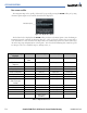
• Intersection, Non-Directional Beacon, and VOR Waypoints (INT WAYPOINT, NDB WAYPOINT, VOR
WAYPOINT) - The INT, NDB, and VOR label size sets the maximum range at which the NAVAIDS names
appear on the display. The zoom range sets the maximum range at which the NAVAIDS appear on the
display:
• INT: off - 30 nm
• NDB: off - 30 nm
• VOR: off - 300 nm
• Airspace Boundaries (CLASS B/TMA, CLASS C/TCA, and CLASS D) - The airspace zoom range sets the
maximum range at which the three classes of airspace appear on the display. The zoom range sets the
maximum range at which the airspace boundaries appear on the display:
• CLASS B: off - 500 nm
• CLASS C: off - 500 nm
• CLASS D: off - 300 nm
• “Other” Airspace Boundaries (RESTRICTED, MOA (Military), OTHER AIRSPACE, and TFR (temporary
flight restrictions). The other airspace boundary zoom range sets the maximum range at which restricted,
MOA, and other (training, caution, danger, warning, and alert areas) airspace boundaries are displayed
• RESTRICTED: off - 500 nm
• MOA (MILITARY): off - 500 nm
• OTHER/ADIZ: off - 500 nm
• TFR: (only present when GDL 69 is installed): off - 2000 nm
Selecting an aviation group item text size:
1) Select the MENU Key with the Navigation Map Page displayed. The cursor flashes on the ‘Map Setup’ option.
2) Select the ENT Key. The Map Setup Menu is displayed.
3) Select the ‘Aviation’ group.
4) Select the ENT Key. The cursor flashes on the ‘ACTIVE FPL’ field.
5) Select the desired aviation option.
6) Select the desired text size.
7) Select the ENT Key to accept the selected text size.
8) Press the FMS Knob to return to the Navigation Map Page.
Selecting an aviation group item range:
1) Select the MENU Key with the Navigation Map Page displayed. The cursor flashes on the ‘Map Setup’ option.
2) Select the ENT Key. The Map Setup Menu is displayed.
3) Select the ‘Aviation’ group.
4) Select the ENT Key. The cursor flashes on the ‘ACTIVE FPL’ field.