
User Guide


GPS NAVIGATION
5-12 190-00494-00 Rev. B
Garmin G1000 Pilot’s Guide for the Cessna Citation Mustang
Nav Range Ring
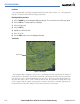
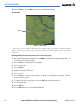
Figure 5-8 Nav Range Ring
Nav Range Ring
The Nav Range Ring (Figure 5-8) shows the direction of travel (ground track) on a rotating compass
card. The range of the Nav Ring is determined by the map range: 125 feet (500 feet map range) to 500
nm (2000 nm map range).
Enabling/disabling the Nav Range Ring:
1) Select the MENU Key with the Navigation Map Page displayed. The cursor flashes on the ‘Map Setup’ option.
2) Select the ENT Key. The Map Setup Menu is displayed.
3) Select the ‘Map’ group.
4) Select the ENT Key.
5) Highlight the ‘NAV RANGE RING’ field.
6) Select ‘On’ or ‘Off’.
7) Press the FMS Knob to return to the Navigation Map Page.
Topo Data
Topographic data can be enabled or disabled on the Navigation Map using the ‘TOPO DATA’ setting.
The topo data range is the maximum map range on which topo data is displayed.
Enabling/disabling topo data and select a topo data range:
1) Select the MENU Key with the Navigation Map Page displayed. The cursor flashes on the ‘Map Setup’ option.
2) Select the ENT Key. The Map Setup Menu is displayed.
3) Select the ‘Map’ group.