
User Guide


GPS NAVIGATION
5-4 190-00494-00 Rev. B
Garmin G1000 Pilot’s Guide for the Cessna Citation Mustang
NAVIGATION MAP PAGE
This section describes the MFD Navigation Map Page setup and operation which in most cases will be a “one-
time” operation since the setup can be customized to accommodate the individual needs of the pilot.
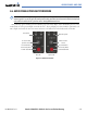
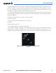
Figure 5-3 Navigation Map Page
(not all map display items shown)
Topo Scale
Nav Range
Ring
Map Range
Legend
Map Orientation
Wind Direction
and Speed
Interstate Highway
Navigation
Course Line
Towered
Airport
MOA
Terrain Scale
NOTE: MFD Navigation Map operations involving the display of traffic, terrain, and weather data are
described in the Hazard Awareness Section.
The Navigation Map Page (Figure 5-3) is the first page in the Map Page Group and provides the following
GPS Navigation display capability:
•Map display showing airports, NAVAIDS, airspaces, land data (highways, cities, lakes, rivers, borders, etc.)
with names (labels)
• Map pointer information (distance and bearing to pointer, location of pointer, name and other pertinent
information)
• Map zoom range legend
• Wind direction and speed
• Heading indication
• Aircraft icon representing present position
• Icons for enabled map features