
Pilot's Guide


Garmin G1000H
™
Pilot’s Guide for the Bell 407GX
190-01255-00 Rev. B390
ADDITIONAL FEATURES
8.2 SAFETAXI
SafeTaxiisanoptionalfeaturethatgivesgreatermapdetailwhenviewingairportsatcloserange.Themaximum
maprangesforenhanceddetailarepilotcongurable.Whenviewingatrangescloseenoughtoshowtheairport
detail, the map reveals taxiways with identifying letters/numbers, airport Hot Spots, and airport landmarks
includingramps,buildings,controltowers,andotherprominentfeatures.Resolutionisgreateratlowermap
ranges.WhentheMFDdisplayiswithintheSafeTaxiranges,theairplanesymbolontheairportprovidesenhanced
positionawareness.
DesignatedHotSpotsarerecognizedatairportswithmanyintersectingtaxiwaysandrunways,and/orcomplex
rampareas. Airport HotSpotsare outlinedtocaution pilots ofareason an airportsurfacewhere positional
awarenessconfusionorrunwayincursionshappenmostoften.HotSpotsaredenedwithamagentacircleor
outlinearoundtheregionofpossibleconfusion.
AnymappagethatdisplaysthenavigationviewcanalsoshowtheSafeTaxiairportlayoutwithinthemaximum
conguredrange.ThefollowingisalistofpageswheretheSafeTaxifeaturecanbeseen:
•NavigationMapPage
•InsetMap(PFD)
•WeatherDatalinkPage
•AirportInformationPage
•IntersectionInformationPage
•NDBInformationPage
•VORInformationPage
•UserWaypointInformationPage
•TripPlanningPage
•NearestPages
•ActiveandStoredFlightPlanPages
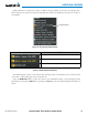
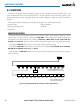
Duringground operationstheaircraft’s position isdisplayed in referencetotaxiways,runways, and airport
features.Intheexampleshown,theaircraftisontaxiwayBravoinsidetheHighAlertIntersectionboundary
onKSFOairport.AirportHotSpotsareoutlinedinmagenta.Whenpanningovertheairport,featuressuchas
runwayholdinglinesandtaxiwaysareshownatthecursor.