
Pilot's Guide


190-01255-00 Rev. B
Garmin G1000H
™
Pilot’s Guide for the Bell 407GX
285
HAZARD AVOIDANCE
SECTION 6 HAZARD AVOIDANCE
The G1000H hazard avoidance features are designed to provide advisory information of potential hazards to
flight safety associated with weather, terrain, and air traffic.
This section is divided into the following groups:
Weather
•GDL69H/69AHXMWXSatelliteWeather(Optional)
•GSR56HGFDSWorldwideWeather(Optional)
Terrain Avoidance
•HelicopterTerrainAwarenessWarningSystem(HTAWS)
Traffic
•TIS(TrafcInformationService)
•GarminGTS800TrafcAdvisorySystem(TAS)(Optional)
6.1 XM WX SATELLITE WEATHER
NOTE: XM WX Satellite Weather data provides information for avoiding hazardous weather. It is not meant
for use to penetrate hazardous weather.
OptionalXM WXSatelliteWeatherisprovidedthroughtheGDL69H/69AH, aremote-mounteddata-link
satellitereceiver.ReceivedgraphicalweatherinformationandassociatedtextisdisplayedontheMultiFunction
Display(MFD)and the Primary Flight Display(PFD)Inset Map. TheGDL69AH can alsoreceiveSiriusXM
entertainmentservices. Bothweather data and entertainmentprogramming operate in theS-bandfrequency
rangetoprovidecontinuousreceptioncapabilitiesatanyaltitudethroughoutNorthAmerica.
ServicesfromSiriusXMaresubscription-based.Formoreinformationonspecicservicepackages,visitwww.
siriusxm.com.
ACTIVATING SERVICES
BeforeXMWXSatelliteWeathercanbeused,theservicemustbeactivated.Serviceisactivatedbyproviding
SiriusXMwithcodedIDsuniquetotheinstalledGDL69AH.SiriusXMSatelliteRadioandXMWXSatellite
WeatherserviceseachhavecodedIDs.TheDataandAudioRadioIDsmustbeprovidedtoXMSatelliteRadio
toactivatetheweatherserviceandentertainmentsubscriptions,respectively.TheseIDsarelocatedon:
•ThelabelonthebackoftheDataLinkReceiver
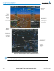
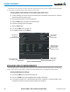
•TheXMInformationPageontheMFD(Figure6-1)
•TheXMSatelliteRadioActivationInstructionsincludedwiththeunit(availableatwww.garmin.com,P/N
190-00355-04)
ContacttheinstalleriftheAudioandDataRadioIDscannotbelocated.