
Cockpit Reference Guide


Garmin G1000H
™
Cockpit Reference Guide for the Bell 407GX
190-01254-00 Rev. B
Appendix
130
Flight
InstrumentsEICAS
Nav/Com/
XPDR/AudioAFCSGPS Nav
Flight
PlanningProcedures
Hazard
Avoidance
Additional
Features
Abnormal
Operation
Annun/
AlertsAppendixIndex
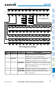
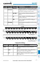
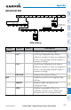
Level 1 Level 2 Level 3
Description
AIRWAYS
Displays airways on the map; cycles
through the following:
AIRWAYS: No airways are displayed
AIRWY ON: All airways are displayed
AIRWY LO: Only low altitude
airways are displayed
AIRWY HI: Only high altitude
airways are displayed
NEXRAD
or
PRECIP
Displays NEXRAD weather and coverage
information on Inset Map (optional)
Displays Worldwide Weather
precipitation on Inset Map (optional)
XM LTNG
or
DL LTNG
Displays XM lightning information on
Inset Map (optional)
Displays Worldwide Weather lightning
information on Inset Map (optional)
METAR
Displays METAR flags on airport
symbols shown on the Navigation Map
LEGEND
Displays the legend for the selected
weather products. Available only when
NEXRAD, XM LTNG, and/or METAR
softkeys are selected.
BACK
Returns to top-level softkeys
DCLTR
Selects desired amount of map detail;
cycles through declutter levels:
DCLTR (No Declutter): All map
features visible
DCLTR-1: Declutters land data
DCLTR-2: Declutters land and SUA
data
DCLTR-3: Removes everything except
the active flight plan