
Cockpit Reference Guide


Garmin G1000H
™
Cockpit Reference Guide for the Bell 407GX
190-01254-00 Rev. B
Appendix
124
Flight
InstrumentsEICAS
Nav/Com/
XPDR/AudioAFCSGPS Nav
Flight
PlanningProcedures
Hazard
Avoidance
Additional
Features
Abnormal
Operation
Annun/
AlertsAppendixIndex
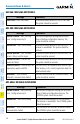
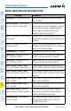
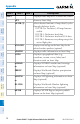
Level 1 Level 2 Level 3
Description
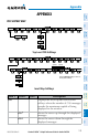
INSET
Displays Inset Map in PFD lower left corner
OFF
Removes Inset Map
DCLTR (3)
Selects desired amount of map detail; cycles
through declutter levels:
DCLTR (No Declutter): All map features
visible
DCLTR-1: Declutters land data
DCLTR-2: Declutters land and SUA data
DCLTR-3: Removes everything except the
active flight plan
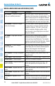
WX LGND
Displays icon and age on the Inset Map for the
selected weather products (optional)
TRAFFIC
Displays traffic information on Inset Map
TOPO
Displays topographical data (e.g.,
coastlines, terrain, rivers, lakes) and
elevation scale on Inset Map
NEXRAD
or
PRECIP
Displays NEXRAD weather and coverage
information on Inset Map (optional)
Displays Worldwide Weather precipitation
on Inset Map (optional)
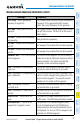
XM LTNG
or
DL LTNG
Displays XM lightning information on Inset
Map (optional)
Displays Worldwide Weather lightning
information on Inset Map (optional)
METAR
Displays METAR flags on airport symbols
shown on the Inset Map (optional)