
User Guide


44
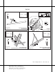
Microsoft Flight Simulator 98 — Pilot’s Guide
Filename: 17316_04.doc Project: Visual User's Guide Template
Template: FS98.dot Author: Larry Boler Last Saved By: Larry Boler
Revision #: 26 Page: 44 of 25 Printed: 07/01/97 01:13 PM
Printed On: Distiller Colorlayer: ? Document Page: 44
San Francisco
N
VAR 16° E
Elevation
Coordinates
ATIS
6
37°43'N
122°13'W
128.5
Oakland, California
Oakland/Metropolitan
Oakland International (OAK)
AIRPORT CHART
For use with
Microsoft Flight Simulator
F
15
33
9
R
9
L
27
L
27
R
11
29
10000 X 150
5453 X 150
6212 X150
3366 X 75
CT
CT
Elevation
Coordinates
ATIS
AIRPORT CHART
For use with
Microsoft Flight Simulator
11
37°37'N
122°22'W
118.85
VAR 16° E
N
San Francisco, California
San Francisco International Airport (SFO)
28 28
L R
1
R
1L
10
L
10
R
19
R
19
L
7001 X 200
8901 X 200
F
CT
11870 X 200
10600 X 200