
User Guide


Microsoft Flight Simulator 98 — Pilot’s Guide
35
Filename: 17316_04.doc Project: Visual User's Guide Template
Template: FS98.dot Author: Larry Boler Last Saved By: Larry Boler
Revision #: 26 Page: 35 of 25 Printed: 07/01/97 01:13 PM
Printed On: Distiller Colorlayer: ? Document Page: 35
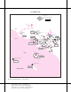
Miami
CT
13000 x 150
9355 x 150
10502 x 200
30
27
L
9R
12
9L
27
R
Elevation
Coordinates
ATIS
11
25°47.6'N
80°17.4'W
119.15
Miami, Florida
Miami International
AIRPORT CHART
For use with
Microsoft Flight Simulator
VAR 4° W
N
MISSED APPROACH
:
Climb to 800' then climbing LEFT turn to 3000' via
270° heading and outbound on DHP VOR R-335 to BRBRA INT/D11.5
DHP and hold.
APPROACH MINIMUMS
:
Straight in approach decision height (DH) 200'
3.8
MM
0.6
M
TCH 51'
TDZE 10'
055°
PJN
242
BRBRA
335°
155°
D11.5
MISSED
APCH FIX
KROME
COPRA
LAWNN
D1.9
4000'
3000'
1500'
090°
MM
D1.9
090°
270° hdg
335°
Opa Locka
DOLPHIN
113.9
090° 110.3 IMFA
ILS DME
LAWNN
COPRA
KROME
ILS Rwy 9L
Miami International
MSA
DHP VOR
2100'
2900'
270°
090°