
User guide
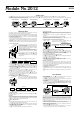

2012-5
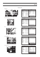
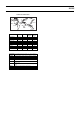
Point name Longitude Latitude
OGASAWARA 142° E27° N 9 6:30
MORETON 153° E27° S 10 10:00
MAUI 157° W21° N –10 4:00
VANCOUVER 126° W50° N –8 1:00
BAJA CA 110° W24° N –7 8:50
BAHAMAS 79° W27° N –5 7:40
CANARY IS 17° W28° N 0 0:00
CORSICA 9° E43° N 1 9:00
ZANZIBAR 39° E6° S 3 3:30
BALI 115° E9° S 8 10:50
GMT
differential
Lunar Tide
Interval
OGASAWARA
Area around Chichijima Island, which is one of the Ogasawara Is-
lands located about 1,000 kilometers south of Tokyo.
MORETON Area around Moreton Island, located just off Brisbane, Australia.
MAUI Area around Maui, located northwest of Hawaii Island.
VANCOUVER Area around Johnstone Strait, Vancouver, Canada.
BAJA CA Area around the central part of the Baja Peninsula, located south
of California in Mexico.
BAHAMAS Area around the Little Bahama Bank, located north of the Grand
Bahama Island.
CANARY IS Area around Gomera Island, which is part of the Canary Islands
(Spain).
CORSICA Ligurian Sea, located north of Corsica (France).
ZANZIBAR Area off of Zanzibar, Tanzania.
BALI Area around Bali, Indonesia.
PRESET LOCATION CHART
OGASAWARA
CORSICA
■ MAUI
BAHAMAS
■
MORETON
VANCOUVER
CANARY IS
■
■
■
■
■ ZANZIBAR
■
■
■
BAJA CA
BALI