
Color Video Plotter GD-1900C user's manual Model 1823C Marine Radar Model 1833C Marine Radar Model 1933C Marine Radar Model 1943C Marine Radar Model 1953C Marine Radar
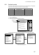
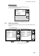

5. CUSTOMIZING YOUR UNIT
5-14
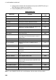
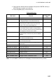
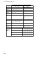
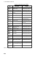
Contents of chart details menu (FURUNO, NavCharts™)
Item Description Settings
Lat/Lon Grid Latitude and longitude grids
Red, yellow, green, light-blue,
purple, blue, white, Off
Text
Information
Geographic place, name On, Off
Waypoints Waypoint size Large, Small, Off
Waypoint
Names
Waypoint name On, Off
Chart Border
Lines
Border lines (indices) On, Off
Landmass
Landmass color, brightness
Bright, Dim: Red, yellow,
green, light-blue, purple, blue,
white.
Off
Background Chart background color White, Black
Navaids
Navaids data on NavCharts™;
lighthouse data on FURUNO
charts
On, Off
Light Sector
Info
Lighthouse viewing sector On, Off
Other
Symbols
Other map symbols
Red, yellow, green, light-blue,
purple, blue, white, Off
Marks Size Marks size Large, Small
Depth < 10 m
On, off, red, yellow, green,
light-blue, purple, blue, white
Depth = 10 m
On, off, red, yellow, green,
light-blue, purple, blue, white
Depth > 10 m
On, off, red, yellow, green,
light-blue, purple, blue, white
CNTOUR
LINE soft key
(See next
page.)
Depth Info
On, off, red, yellow, green,
light-blue, purple, blue, white