
User's Guide
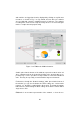
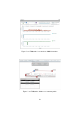
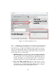
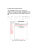
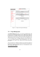
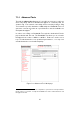
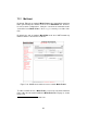
Table Of Contents

ful to add a map of the area in which the Fluidmesh system is deployed.
2
Map images can be uploaded to the Mesh End unit using the proper button
placed in the FMQuadro top toolbar. Common image formats are supported
including png, jpg and bmp. Furthermore, whenever an Internet connection
is available to the user PC used to configure the Fluidmesh network, Google
Maps map can be used to set the background of FMQuadro.
3
The top tool-
bar provides several intuitive buttons to drag & drop the background map
and control its transparency and scale. Once the map is set up, the FM
units can be dragged to their actual installation places. Finally, the modified
layout can be saved and used again in the future.
As the FMQuadro engine collects statistics from the entire network through
the Mesh End unit, it is no longer necessary to directly connect to remote
units. The overall network status and individual device status can be moni-
tored real-time through the FMQuadro interface on Mesh End unit.
2
Aerial images can be downloaded using Google Earth (http://earth.google.com/).
3
Please note the you need an Internet connection to use the Google Maps background
feature.
52