
User's Guide
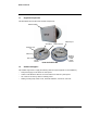
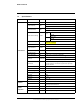
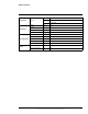
Table Of Contents
- Table of Contents
- Radar Overview
- Installation
- 2.1 Configuring the Radar for Networking
- 2.2 Radar Placement and Orientation
- 2.3 Site Preparation
- 2.4 Installing the Wall Mount Bracket
- 2.5 Connecting the Radar and Installing the Back Box
- 2.6 Installing the Radar Assembly
- 2.7 Uploading a Map Image and Configuring Georeference Settings
- 2.8 Aiming the Radar and Testing Target Detection
- 2.9 Defining Analytics Regions
- 2.10 Pairing a PTZ Camera with the Radar (Optional)
- Operation
- Configuration
- Maintenance and Troubleshooting Tips

427-0101-01-12 Revision 100 September 2020 3
This document does not contain any export-controlled information.
Radar Overview
1.3 Specifications
Specification Unit Elara Radar Model R-290
Performance
Radar FOV ° 90 x 30
Radar Frequency GHz
USA: 24.075-24.175 GHz ISM Band
Europe: 24.000-24.250 GHz ISM Band
RF Transmit Power dBm
FCC: 14 (0.025W)
EU: 6 (0.005W)
Radar Detection Range meters
FCC
Human: 250
Car: 600
EU
Human: 150
Car: 300
Target Detection Speed
Minimum: 0.1 m/sec
Maximum: > 100 km/h
Number of Tracks 64
Range Resolution meters
FCC: 1.5
EU: 0.6
Distance Accuracy meters < 1
Azimuth Accuracy ° 0.6
Sensor Scan Rate Hz 10 Hz, 5 Hz, or 2 Hz (user-configurable)
Coverage
Acres (m
2
)
FCC Human Detection: 12 acres (48,500 m
2
)
EU Human Detection: 4 acres (16,000 m
2
)
Object Data
GPS coordinates, velocity, RCS, range, azimuth angle/
direction, heading, course/track, doppler width, object type,
target ID, duration
Object Classification Human, vehicle
Analytics Embedded tracker and classifier
Data Streaming All object data
Wi-Fi Range meters 50
GPS Spec
TBD
Pan Range ° +/- 43°
Tilt Range ° +30° / -60°
Interface
Number of I/O 1 in, 1 out (isolated, 4 conductors)
Connectors
10/100 Ethernet
I/O and power terminal block
System
Integration
Connectivity 10/100 Ethernet
Network APIs FLIR SDK, FLIR CGI, ONVIF Profile S
Supported Protocols AXML, XML, KML, Google Earth