
User's Manual

Software User Manual
©FJ Dynamics Technology Co., Ltd. All rights reserved.
80
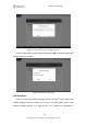
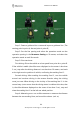
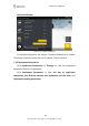
Figure 3.7.12 GNSS Receiver Offset Calibration
Step 1: Create a guidance line: create and import a guidance line. (The
starting point is point A, the end point is point B)
Step 2: Set the line spacing and select the operation mode: set the
operation spacing in the Parameter Setting to 10 meters, and select the
operation mode as multi line mode.
Step 3: Drive two times.
First driving: Drive the vehicle at a low speed from point A to point B.
If the vehicle is stable (the offset error displayed on the screen is less than
2 cm), stop after the driving distance is not less than 10 meters, and mark
at the right rear tire position of vehicle, confirming the marking line L1.
Second driving: After marking the marking line L1, turn the vehicle
around and continue driving in the reverse direction along the driving
route just now. When driving to the vicinity of the marking line L1 in the
second step (note: ensure that the driving status is stable at this time, that
is, the offset distance displayed on the screen is less than 2 cm), stop and
draw the marking line L2 at the left rear wheel position.
Step 4: Measuring error: use a clicke measure to measure the distance
between the two marking lines, and record the value a (unit: m)