
User Manual


Guilin Feiyu Electronic Technology Co., Ltd.
Guilin Feiyu Electronic Technology Co., Ltd http://www.feiyu-tech.com service@feiyu-tech.com
Page 36
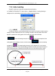
All the steps finished successfully, it will generate 3 format files with the same name,
respectively ―.gst‖, ―.tab‖, ―.jpeg‖ files. The Generating ―.gst‖ file is the map file format that
the 2D version GCS can support, after loading it you can do the route planning.
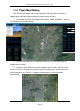
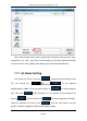
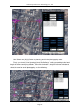
11.7 Air Route Setting
Click ―Route‖ on Tool bar, Then click ― ‖ , waypoint position which you want.
You can through the ― ‖ to set waypoint
altitude(default is 200m). Click right mouse button on ― ‖ for ending waypoint
plan. Then click ― ‖. After uploading, you can clear the current waypoints via
click the ― ‖ button. And then click ― ‖, download waypoints in PandaⅡ,
check the waypoints are correct. Click ― ‖, save the route which is set into
pandaⅡ, otherwise waypoints will be lost after power outage.