PandaⅡGCS & AFSS Autopilot System Installation & Operation Manual Applicable To The Firmware V1.21 And Above Guilin Feiyu Electronic Technology Co., Ltd Addr : 4th Floor,YuTaiJie Science Technology Building,Information Industry Park , ChaoYang Road ,Qi Xing District ,Gui Lin ,541004 Website: www.feiyu-tech.com Email: service@feiyu-tech.
Guilin Feiyu Electronic Technology Co., Ltd. Table Of Content User Agreement ......................................................................................................................................2 1. PandaⅡAutopilot System Introduction ............................................................................................3 2. Major AutoPilot Components ...........................................................................................................4 3.
Guilin Feiyu Electronic Technology Co., Ltd. Dear Pilot Thank you for purchasing the PandaⅡ Full Function Autopilot with GCS & AFSS from FeiYu Tech. In order to achieve full potential and safe operation of this product, please carefully read this manual prior to installation. This manual applies to PandaⅡ firmware V1.21 and above , version 5.1 GCS or above . User Agreement a) The PandaⅡ autopilot system complies with all regulations within the People‘s Republic of China (PRC).
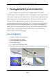
Guilin Feiyu Electronic Technology Co., Ltd. 1. PandaⅡAutopilot System Introduction PandaⅡ Autopilot mainly include: PandaⅡ Autopilot module, GPS module, Airspeed module, Power management module, Remote adapter module, communication system, GCS. Through our GCS software you can set flight waypoint, flight altitude, flight speed, Equidistance or Timing taking photo and so on.
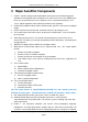
Guilin Feiyu Electronic Technology Co., Ltd. 2. Major AutoPilot Components 1. PandaⅡ provides high-precision flight attitude measurement and control through the utilization of an integrated 32 bits microprocessor, GPS receiver, three-axis MEMS gyros, three-axis accelerometer, three-axis magnetic sensor, accurate barometric pressure sensor, attitude algorithm, Kalman filtering and data fusion algorithms. 2. Combined the attitude module and the control module, get more small volume and lighter weight. 3.
Guilin Feiyu Electronic Technology Co., Ltd. latitude, altitude, speed, etc . 14. The GCS software helps integrate Automated and Manual flight control modes in an easy to use display interface. 15. The GCS software includes electronic map formatting. By using the electronic map, aircraft route and tasks can be modified in real-time via your GCS computer. 16.
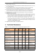
Guilin Feiyu Electronic Technology Co., Ltd. Flight status PID Control Rate 100 Hz Navigation Control PID Rate 10 HZ 1 Hz Maximum 10Hz 1 Hz Maximum 10Hz 1 Hz Maximum 10Hz 19200 Bps TTL Level Data Telemetry‘s Track Frequency Data Telemetry‘s Mission Frequency Data Telemetry ‗s Flight Status frequency RS-232 Baud Rate Operating Temperature -20 25 Temperature ℃ 60 ℃ 25 4. PandaⅡ Instructions No.
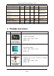
Guilin Feiyu Electronic Technology Co., Ltd. Use for measure the airspeed 4 volume:64.5mm * 13.5mm * 13.5mm Weight:9g Turning receiver signal to digital signal for data radio 5 Volume:52mm * 33.5mm * 14mm Weight:26g 1.Connect Data Radio and PC 6 2.Connect Remote Adapter and PC 3.
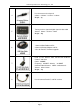
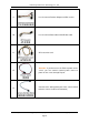
Guilin Feiyu Electronic Technology Co., Ltd. 9 Use for connect Remote Adaptor and RC receiver 10 Use for connect Data radio and USB data cable 11 GPS extension cord Attention: If you do not use the ESC to power on the 12 servos, you can connect external power source to power on the servos through P2 port. 13 Connect to the taking photo port of the camera.(Need to do the camera shutter transformation) Guilin Feiyu Electronic Technology Co., Ltd http://www.feiyu-tech.
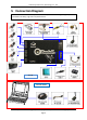
Guilin Feiyu Electronic Technology Co., Ltd. 5. Connection Diagram OPTION 1: RC receiver directly connect to Panda Ⅱ. The maximum flight range is your RC Transmitter. No delay, high real-time performance. Aircraft Ground Station Guilin Feiyu Electronic Technology Co., Ltd http://www.feiyu-tech.com Page 9 service@feiyu-tech.
Guilin Feiyu Electronic Technology Co., Ltd. OPTION 2: The Data Radio range will dictate your flight range. Additionally, due to the digital signal conversion and processing, some delay in manual control transmission will occur Aircraft Ground Station Guilin Feiyu Electronic Technology Co., Ltd http://www.feiyu-tech.com Page 10 service@feiyu-tech.
Guilin Feiyu Electronic Technology Co., Ltd. 6. S1~S8 Servo Interface Connection Instructions No.
Guilin Feiyu Electronic Technology Co., Ltd. The wire connection about power management module. The wire module. connection about GPS 2*4P RC receiver connecting wires, use for connect the RC receiver and PandaⅡ,the wires is arranged by the colors. White (Bundled with red & black) —— AIL; Orange —— ELE; Green —— THR; Yellow —— RUD; Brown —— CH5; Blue —— CH6 The FY-606 Data radio connecting wires. The Airspeed wires.
Guilin Feiyu Electronic Technology Co., Ltd. Vibration absorbing pads (dampers),use for Panda Ⅱ vibration damping installation. 2*5P RC receiver connecting wires, use for connect the RC receiver and Remote Adaptor, the wires is arranged by the colors. Yellow——AIL; White (bundled with red & black) ——ELE; Orange——THR; Green——RUD; White——CH5; Red——CH6; Blue——CH7; Brown——CH8 The wire connection about Remote Adaptor and FY-602 Data radio. The wire connection about Remote Adaptor and USB data cable.
Guilin Feiyu Electronic Technology Co., Ltd. 8. The Installation Of Main Module 8.1 PandaⅡ Module Installation The Autopilot module must be placed horizontally and as close as possible to the plane‘s CG (Center of Gravity). The default direction is the arrow direction must be pointing towards the nose of the plane (i.e. direction of flight). You can change the direction to four directions via the GCS software, i.e direction forward, back, left, right (shown below) .
Guilin Feiyu Electronic Technology Co., Ltd. 8.2 GPS Module Installation GPS module including a flat-GPS passive antenna. This is a sensitive antenna for GPS signals, while false signals reflected from the ground is effectively filtered out. Install the GPS unit horizontally. Keep metal objects and other conductive materials such as carbon fibre away from the GPS unit. Additionally no transmitting antenna should be around the GPS antenna.
Guilin Feiyu Electronic Technology Co., Ltd. 8.5 Airspeed Sensor Module Installation The airspeed sensor need to pull ahead the front of the pneumatic opening and in the line with the direction of flight. You can install the Airspeed sensor to the wing or in the front of the nose, do not block the front of the air inlet , we can use the glue to fix the airspeed sensor. Note: Make sure that after installation, the fuselage in flight airflow can not interfere with air intakes. 8.
Guilin Feiyu Electronic Technology Co., Ltd. 9. PandaⅡ Indicator Light Instruction PandaⅡ with three colors LED which can send out red, blue, green light. Also yellow, white, purple and other colors light through the combination. Operators can know the PandaⅡ‘s operating mode by judging the different colors which the LED sends out and the flash frequency. green light flash means GPS location fixed, red and blue light indicate PandaⅡ working mode.
Guilin Feiyu Electronic Technology Co., Ltd. 10. RC Setting, SW1&SW2 Channel Setting PandaⅡ requires a minimum of 6-channel RC receiver.4 Receiver channels are used for aileron (channel 1), elevator (channel 2) ,throttle (channel 3) and rudder (channel 4) signal output. 2 free Receiver channels are required to control the PandaⅡ Flight Modes (a 3-position switch or dial knob, ‖SW1‖) and Autopilot Mode (a 3-position switch or dial knob, ‖SW2‖).
Guilin Feiyu Electronic Technology Co., Ltd. The FYGCS5.1 software include Google earth live map, also can support 2D view and 3D view at the same time. Support in offline mode display the map which have been browse . FY-GCS5.1 Software Operating Requirements CPU Frequency: 1GHz or more. Memory Capacity: 1G or more. Hard Disk Space: At least 200MB free disk space Operating System: Windows XP system, Vista, Win7system, etc Monitor Resolution: 1024x768 or above. First you have to download the FYGCS 5.
Guilin Feiyu Electronic Technology Co., Ltd. The “COM * ” is the virtual serial number of the USB-TTL cable. 11.2 Install Google Earth Plugin 6.1 Version Or Above Two methods to install the plug-in . Method one: Networking installed directly Method two: Install the local plug-in provided by us , you can download at our official website: www.feiyu-tech.com Method for checking whether the Google Earth plug-in have been installed successfully. Enter the following url : http://www.google.
Guilin Feiyu Electronic Technology Co., Ltd. 3)Confirmation has been connected to the network , click the ―3D‖button ,you can Switch to the Google earth map. Note: If you can’t open FYGCS5.1 successfully in Vista or Wind7 operating system . Please find out executable file, right click the mouse and run as administrator. Guilin Feiyu Electronic Technology Co., Ltd http://www.feiyu-tech.com Page 21 service@feiyu-tech.
Guilin Feiyu Electronic Technology Co., Ltd. 11.4 Connect PandaⅡ To Our GCS Software When you finish the flight control system installation and power on the whole system. Please choose the right COM"X"(Like:COM1),baud rate:19200 and click on "Connect" button, this time will pop-up a ID setting dialog box .Enter the ID number of the PandaⅡ , click ―OK‖ button, it will pop-up a dialog box to prompt record the log file, choose the save path , you can change the file name . Click the ―save‖ button .
Guilin Feiyu Electronic Technology Co., Ltd. enter the correct ID number on the GCS ,it can establish connection with PandaⅡ .This function can effectively avoid the problem which interference the control of the Padan2 because using the data radio in the same frequency . Firmware for PandaⅡ below V1.2 Version Please enter “00000” in the ID setting dialog box. Setting ID number The default ID number is ―00000‖. Users can enter any number between 00000~65535.
Guilin Feiyu Electronic Technology Co., Ltd. The result of bounding will show in the information bar. After bounding succeed unplug the jumper. Autopilot bounding succeed : Autopilot bounding Failure : Guilin Feiyu Electronic Technology Co., Ltd http://www.feiyu-tech.com Page 24 service@feiyu-tech.
Guilin Feiyu Electronic Technology Co., Ltd. Note: Remote Adapter which purchase before October 22, 2013 are not support the setting ID number function .When you use the PandaⅡ you can set its ID number as “00000”.If you want your Remote Adapter work in this new function ,please sent it back to our company to upgrade . 11.5 Configurate The PandaⅡ Via “Autopilot Configuration Wizard” Select ―Menu---Autopilot Configuration Wizard‖ begin doing basic configuration of PandaⅡ.
Guilin Feiyu Electronic Technology Co., Ltd. Step Two: Servo’s output mix control mode setting No. Option Normal Elevon V tail Airship No MIX ELE&AIL MIX ELE&RUD MIX No MIX “AIL NAV‖means using only aileron make a turn in navigation mode. ‖RUD NAV‖means using only rudder make a turn in navigation mode. Guilin Feiyu Electronic Technology Co., Ltd http://www.feiyu-tech.com Page 26 service@feiyu-tech.
Guilin Feiyu Electronic Technology Co., Ltd. Step Three: Servo Control Reverse setting Please use your RC control sticks to control the aircraft servos movement to see if they are in the same control direction of your RC control sticks. And if not, please adjust your RC to make them right. Switch to the "Auto Balance Mode" mode, check the control direction as explained below. Please according to the following checking and setting methods to make sure the servo control direction is correct.
Guilin Feiyu Electronic Technology Co., Ltd. AILERON (Check in "Auto Balance Mode" ) RIGHT Roll the plane , the right aileron should automatically move downwards, while the left aileron move up. LEFT Roll the plane , the left aileron should automatically move downwards, while the right aileron should move up. If the servo movement is incorrect, you need to reverse the automated servo movement please select ―AIL REV‖.
Guilin Feiyu Electronic Technology Co., Ltd. Rudder (check in "Auto Balance Mode" ) CLOCKWISE rotate your plane , the rudder should move to the Left. COUNTER CLOCKWISE rotation ,the rudder should move to the Right If the servo movement is incorrect, you need to reverse the automated servo movement please select “RUD REV”.
Guilin Feiyu Electronic Technology Co., Ltd. Step Four: Basic sensitivity Settings for automatic control We suggest that the first flight should be in default value ,then adjust the value according to the actual flight . Adjustment principle: check the gain of stability whether it is normal in the "Auto Balance Mode ―.
Guilin Feiyu Electronic Technology Co., Ltd. Step Five :The cruise speed and hovering flight radius setting Target speed setting (Default setting is 60km/h).The flight speed is very important, you can not optional Settings. The speed must can keep aircraft keep normal flight. We suggest not increase the settings too high, it may cause very unusual flying behavior and may result in damage of your aircraft due to excessive throttling.
Guilin Feiyu Electronic Technology Co., Ltd. Step Six: Gyro and airspeed sensor Initialization Gyro Initialization : Please click on the ―Initialize the gyro‖ button to do the gyro reset. When doing the gyro reset, please keep the PandaⅡ static and you can not to do the gyro rest during the flight. It‘s better to do the gyro reset before each flight.
Guilin Feiyu Electronic Technology Co., Ltd. 11.6 Flight Map Making GCS 5.1 only can display and set the flight path in 2D view ,We can make the Google earth map into the flight map which can be use the 2D view. 1 ) Confirmation has been connected to the network , hidden the toolbar , make the GCS software to maximize window . 2 ) Click the ―3D‖button switch to the 3D view ,then fine out the flight region on Google earth live map .
Guilin Feiyu Electronic Technology Co., Ltd. 4 ) After selected the area, click the ―Make Map‖ to grab the map . In the process of grabbing the map, you can‘t do any operation, click and move the mouse is also forbid ,wait for finish grabbing the map. According to the size of the region and the desired picture definition the larger area, the lower height, then the picture size is larger, and the map loading is more slower .
Guilin Feiyu Electronic Technology Co., Ltd. Note: The greater the size of the region ,the greater the number of pictures need to grab ,too many pictures may cause the failure of map making .Total number of map making should be controlled less than 512 pictures .)In GCS 5.1 The default value of screenshot resolution is ‖high‖ . In the same conditions, the higher the screenshot resolution, the clearer map which make in 3D view.
Guilin Feiyu Electronic Technology Co., Ltd. All the steps finished successfully, it will generate 3 format files with the same name, respectively ―.gst‖, ―.tab‖, ―.jpeg‖ files. The Generating ―.gst‖ file is the map file format that the 2D version GCS can support, after loading it you can do the route planning. 11.7 Air Route Setting Click ―Route‖ on Tool bar, Then click ― ‖ , waypoint position which you want. You can through the ― ‖ to set waypoint altitude(default is 200m).
Guilin Feiyu Electronic Technology Co., Ltd. Use ―Select rect (H)/(V)‖button to planning arch Aerial photography route . Firstly ,you should ‖Line Spacing(s)‖and ―Dis Buffer(s)‖ setting ,according to the focal length of camera and flying altitude , then click the button , drag the left mouse button to select the area for aerial photography, as the following: Guilin Feiyu Electronic Technology Co., Ltd http://www.feiyu-tech.com Page 37 service@feiyu-tech.
Guilin Feiyu Electronic Technology Co., Ltd. 11.8 Auto Landing PandaⅡ system can select the method of the auto landing as ‖LINEAR‖or‖PARACHUTE . Select ―Menu---Autopilot Setting---Landing Setting‖to configurate the auto landing model and the altitude of open parachute. ( 1 ) LINEAR In order to realize the auto landing function you need to set 2 point to make sure the landing air route before take-off.
Guilin Feiyu Electronic Technology Co., Ltd. 1) Click on to start auto landing, first the aircraft will fly to circling point ―C‖. 2) When it reaches point ―C‖, it's will auto circling around point ―C‖, and gradually decline to 50 meters. 3) The aircraft will continuous to decline the altitude to proper position , according to the distance of the plane to the "landing end point" and then at the right time to cut into A-B route .
Guilin Feiyu Electronic Technology Co., Ltd. Auto Take Photo Waypoint Setting (Enter the serial number of waypoint.) Starting waypoint: during the path navigation mode , auto take photo will be trigger at this waypoint Ending waypoint: during the path navigation mode, auto take photo will be close automatically at this waypoint. The photo point will be mark with a small yellow flags on the map .
Guilin Feiyu Electronic Technology Co., Ltd. 2) After the wires connection is OK, USB-TTL data cable connected to the computer USB port, open the GCS software. 3) Read the current parameter values. 4) Parameters reading success Guilin Feiyu Electronic Technology Co., Ltd http://www.feiyu-tech.com Page 41 service@feiyu-tech.
Guilin Feiyu Electronic Technology Co., Ltd. 5) After read the current parameters, you can configure the channel . In the channel drop-down menu to select the channel which you need to configure. 6) Click on the "SET", underside column will indicate the parameter setting success. After setting success, you can close the dialog box directly . Considerations For Data Radio Setting 1) Only in the same channel , the data radio can communicate with each other.
Guilin Feiyu Electronic Technology Co., Ltd. information (if there is no storage space already, but you still taking photo, it will through cover the first generate file to record the new file, it will through cover the first generate file to record the new file). You can connect the Panda2 to the GCS software through the Data Radio to read the photo-taken POS information (only after GPS positioning success that will be generated the information file).
Guilin Feiyu Electronic Technology Co., Ltd. ―Save File‖ Choose the file you want to save from file list title display field, click ―Save file. The file will be saved to your computer. In the Pop-Up dialog, select the desired file save path, input the file name (Please added . txt filename extension). Open .txt document, every data is separated by ―,‖ and a line of data is created in every photo-taken. Instructions Of Every Data Type of command Pos information Fields 1 Photo serial No.
Guilin Feiyu Electronic Technology Co., Ltd. 11.12 Auto Take-off Setting And Debugging Attack angle: Use this to adjust the Auto take-off pitch setting(default is 25 deg). Take Off Throttle: We suggest you set to 90. Automatic take-off is not suitable for all model aircraft, it's more suitable for hand or catapult take-off aircraft. We take throwing take off aircraft for example, after set the automatic take-off parameter, please prepare for throwing take off. Click on .
Guilin Feiyu Electronic Technology Co., Ltd. Connection by ―Option 1‖, RC receiver connect to the PandaⅡ directly ,it need the RC and RC receiver both must have ―Fail-Safe‖ function .Setting SW2 switch ,when RC out of control, the SW2 signal will switch to " Return To Launch (RTL)" position. Data radio communication interrupt Return To Home Connection by ―Option 2‖,RC receiver connect to Remote Adaptor.
Guilin Feiyu Electronic Technology Co., Ltd. sticks to control the aircraft servos surface to see the movement is right or not. ( 6 ) To check the servo control surface automatic movement and setting install direction, also the airspeed and altimeter. First, you should switch"SW2" to "NULL" mode, then switch "SW1" to the " Stabilized Mode ".
Guilin Feiyu Electronic Technology Co., Ltd. positioning success. At the same time you can see the icon of the aircraft on the GCS software. ( 9 ) Setting a simple routes, for example, you can set a rhombus routes ,its length is about 500 meters , the height of Waypoint is 200 meters. (10) Set the Home point: After power on,PandaⅡ will take the GPS first location point as Home Point. But you also can through button to set the new Home Point.
Guilin Feiyu Electronic Technology Co., Ltd. Balance Mode. While flying in a straight line and having no input through the transmitter sticks. Please through the to record servo neutral. (16) Target speed setting (Default setting is 60km/h).The flight speed is very important, you can not optional Settings. The speed must can keep aircraft keep normal flight.
Guilin Feiyu Electronic Technology Co., Ltd. waypoint. 13.3 PID Parameters Instruction And Adjust The PID parameters adjust require you have professional knowledge. The three values of each parameters from PID control menu correspond: Proportional, integral, and damping ―Turn Control‖-------Control the angle of roll when the aircraft use aileron navigation. Up/down Data Frequency "Teleme Rate" refers to the flight control data downlink frequency.
Guilin Feiyu Electronic Technology Co., Ltd. 2 ) Connect PandaⅡ to our GCS software, using aerial photography route planning function to set a Line Spacing 200m,Distance Buffer 200m, altitude 200m route and upload the route. Set every 4 seconds to automatic take a photo. Cancel the Route loop function . 3 ) According to the flight space set the landing point, planning out of the land routes. 4 ) Open the camera and make sure the camera is ready. 5 ) Prepare for throwing take off. Click on .
Guilin Feiyu Electronic Technology Co., Ltd. 4) Start to upgrade, wait to upgrade success. This manual is just a guideline to help you set up your aircraft for autonomous flight. As each aircraft is unique, you will need to fine tune the settings to suit your aircraft‘s flight characteristics. –––– END –––– Note: We reserve the right to change this manual at any time! And the newest edition will be shown on our website www.feiyu-tech.com. Guilin Feiyu Electronic Technology Co., Ltd http://www.