
Manual

Guilin Feiyu Electronic Technology Co., Ltd
Guilin Feiyu Electronic Technology Co., Ltd http://www.feiyudz.cn service@feiyu-tech.com
37
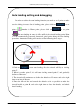
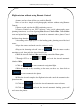
Aerial photography route planning
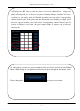
Our GCS software provided Aerial photography route planning function
which you can choose Horizontal or Longitudinal planning routes in the selected
area. You need to input three parameters: Line Spacing, Distance Buffer, altitude.
We take a Horizontal planning routes with Line Spacing200m,Distance
Buffer200m, altitude200m as a example. Click the button ― ‖, then drag
right mouse button to select the area for aerial photography, as the following:
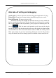
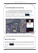
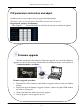
Route Loop function
The default path navigation in Panda2 is auto repeat .when the plane fly over the last
waypoint it will fly back to the first waypoint. You can cancel this default value via the
GCS software button, then the plane will not fly back, just circle in the last
waypoint.