
User`s guide
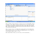
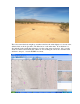

Overlaying the road map instead of the satellite map… not very interesting here because it’s
about 8 miles to the nearest road.
Now, this is interesting and pretty, but it doesn’t tell you exactly where your rocket landed. If
you have a smartphone, you can use the coordinates to tell you where to go (more on that in a
bit). If you do not have a smartphone, MapSphere does provide a relatively easy way to tell
you which direction to go. Simply use the Ruler tool from the first location (your launch site)
the last location (the landing spot), and it will give you the compass heading and the distance.
If you take off in the general direction of the compass heading, chances are very good that you
will find your rocket, as long as the rocket has landed out in a relatively open area.
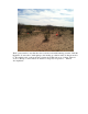
If you have trees, tall grass, or in this case sagebrush, you are definitely going to need to have
some kind of GPS-assisted help to take you to the landing spot. What you need to do is to save
the track by exiting out of MapSphere (it will give it a name with the date and time in the
filename, so it will be easy to find). It would be nice if this data were a simple NMEA data
dump, unfortunately they have their own format, but it is fortunately easy to get the location
from it since it’s a text file.
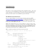
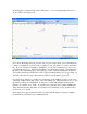
Open up the saved .gpx track file file with a text editor like Notepad or Notepad++ (highly
recommended!), and it will look something like this: