
User`s guide

There are a number of map sources that you can choose from, we recommend Microsoft Live
Search Maps - Aerial. Having a satellite map will help in many cases, but if the location that
you are flying is surrounded by roads then you may want to use the “Microsoft Live Search
Maps – Streets” map instead. Sometimes the streets provide better visual clues of where your
rocket went than the satellite map.
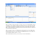
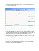
This is an example of what a “real” flight track looks like, this is from a J-class flight with a
Giant Leap Escape Velocity to about 8,300’ at the TRAPHX Eagle Eye site near Aguila, AZ
(using an Eggtimer Flight Computer, of course).
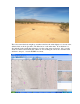
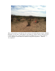
This is what the field looks like: (you can see why you’d need a tracker there…)