
User`s guide

Assuming that your frequency is clear, connect your Eggfinder TX to the battery. The RED
PWR LED should come on, indicating that you have power. Like the Eggfinder RX receiver,
if the GREEN LED on the Hope RF module starts blinking that means that somebody else is
transmitting on your frequency… figure out who it is before you start transmitting.
If your frequency is clear, hold the button on the Eggfinder TX down until the GREEN RDY
LED comes on (it should take about a second), then release it. The GPS module will start
searching for satellites to get a position lock, typically this will take about 30-60 seconds
outdoors, but if you are testing indoors it may take as long as 10 minutes. The RED LED on
the Hope RF module will start flashing immediately, and the GREEN LED on your Eggfinder
RX receiver’s Hope RF module will start flashing in sync with your Eggfinder TX. Once the
GPS module has a good GPS lock (at least 4 satellites), the AMBER 1S LED will start
blinking, once per second, indicating that you have lock. Once this happens, you can start up
the software on your laptop/tablet to start tracking your Eggfinder TX’s movements.
After you find your rocket, you should turn off the Eggfinder TX by holding the button down
for at least one second, until the GREEN RDY LED turns off. You may then disconnect the
battery. Depending on your software on the laptop/tablet, you may want to turn off the
Eggfinder RX (by unplugging the USB cable) before you retrieve your rocket, or after you
return to your launch site. If you have interfaced the Eggfinder RX board to a Bluetooth
module so you can use it with a tablet, you’ll probably want to take it with you as your retrieve
your rocket, and turn it off after you’re done.
GPS Software
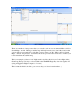
The software that you use to help find your rocket can be as simple as a terminal program that
you use to simply download the NMEA data stream (using the “last received” $GPGGA record
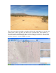
to give you the coordinates of your rocket’s landing spot), or as sophisticated as a GPS
mapping program that shows you in real-time where your rocket is going, with a satellite map
overlay. The requirement is that it must be able to handle NMEA-formatted GPS input from a
serial port. In the case of a serial terminal program, it’s just going to spit it out on the screen;
it’s up to you to interpret the data. Most people will want to use a mapping program, it makes
life much easier. On the other hand, may map programs require Internet access, and that may
not be available at your launch site, so simply having the landing coordinates in most cases is
all you need to find your rocket.
Some programs that we’ve tried include:
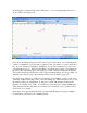
Serial terminal programs
PuTTY
Hyperterm
Simple GPS data display programs (limited mapping capabilities)
VisualGPS