
User Manual

USER GUIDE
70
6.15.4.3 Additional Basic Numeric Readouts
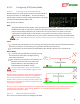
Home Arrow: The home arrow points straight up if you are presently flying toward home. If you are using
the magnetic compass, the compass is used to determine the home direction. If you are not using the compass,
the GPS course is used.
If the compasss is not being used, and the model is moving very slowly or not at all relative to the
ground, the home arrow will not be accurate, and may display a “?”.
Callsign: This readout lets you program your amateur radio call sign, to be displayed for 15 seconds every 10
minutes. The call sign is programmed using the stick menu: left and right select the position to be changed,
and up and down changes the character for that position.
Flight Time remaining: This readout shows the approximate flight time remaining, based on your pack mAH
setting, and the present amp draw on the battery. This readout is only meaningful if you are flying with a
relatively constant amp draw.
Receiver RSSI: This is the RSSI (Received Signal Strength Indicator) percentage, derived from the
MicroVector’s RSSI input pin described earlier. Note: if the RSSI input was not correctly connected during the
Receiver Analysis Wizard, the RSSI indicator will show a “?”.
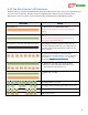
GPS Position (Lat/Lon): The “Force Lat/Lon display when?” setting determines when the GPS position will be
displayed on the screen.
The settings are as follows:
Never: GPS position is never displayed
Trouble: GPS position is displayed when radio failsafe is detected, if RTH is triggered, or if an alarm has been
triggered.
Low Alt: GPS position is displayed for Trouble, and additionally will display if the present altitude is less than
100 feet/30meters.
Distance: GPS position is displayed for Trouble, Low Alt, and additionally if the distance of the model from
home exceeds the “RADAR Maximum Radius” menu item in the “Graphics and Indicators Setup” menu.
Always: GPS position is always displayed
You can change the format of the displayed GPS position, depending on your requirements. See section
8.6.1 – ‘Choosing the GPS Position Display Format’.
GPS Satellite Count: This readout shows the number of satellites being used by the GPS
GPS Course: This shows the present course being returned by the GPS.
6.15.4.4 Units display
If “Display Units for All Items” is set to Yes, the units will be displayed for each readout that has units.
6.15.5 Advanced Numeric Readouts
The MicroVector has a wealth of parameters that can be configured for display, and, you can also customize the
MicroVector to display numeric readouts on multiple screens, move the readouts around on the screen, and
configure advanced features of the readouts, such as displaying “gauge” and “swatch” readouts.