
User Manual

USER GUIDE
69
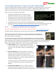
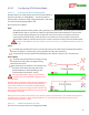
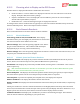
6.15.3 Choosing what to Display on the OSD Screen
The MicroVector’s displayed information is divided into three classes:
Numeric readouts - numeric readouts are displayed on the first two rows and last two rows of the
display. Examples: RSSI, motor battery voltage.
Graphics and Indicators– these are displayed in several different places on the screen. Examples:
altitude and airspeed ladders, compass.
Notification area – status and warning messages are displayed in this area
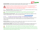
To configure basic numeric readouts that are typically used, select the “Numeric Readouts Setup” menu item
from the OSD Setup menu. Here’s a description of these readouts:
6.15.4 Basic Numeric Readouts
Here is some information on the basic numeric readouts available:
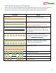
6.15.4.1 Electrical Readouts
Pack Voltage, Pack Current, Pack mAH Used: These display
information about your main flight pack, which must be connected to
the current sensor for these readouts to be valid.
Video Tx Voltage: This is the voltage being supplied to the “Vid Tx”
plug “E” on the video harness. This readout would normally be
displayed only if you are using a second video battery.
Receiver Voltage: This is the voltage being supplied via the red wire of the receiver connection harness, or via
the power pins of the MicroVector servo outputs.
6.15.4.2 Altitude, Speed and Distance Readouts
Barometric Altitude: This displays the present barometric altitude of the model from the built in pressure
sensor, which is zero referenced (set to zero) when the MicroVector is powered up.
GPS Altitude: This displays the present GPS provided altitude, assuming there is a 3D GPS fix. This is also set
to zero at power up.
Both the GPS and barometric altitudes are zeroed when you select the “Reset Home Position” option
from the main menu, and for multirotors, each time you arm.
GPS Groundspeed: This displays the horizontal speed the model is moving over ground, as reported by the
GPS. Note that this speed is not the actual airspeed of your model, if there is any wind.
Pitot Airspeed: If you have the optional pitot airspeed sensor, this displays the airspeed.
Numeric Climbrate: This displays the model’s climb or descend rate.
Distance To Pilot: This displays the horizontal distance between the home point and the model, as reported by
the GPS.
Initially, this readout is in the units selected for distances in the English/Metric Units Setup menu described
above. But, when the distance exceeds 1km (for metric system units) the display switches to kilometers. Or, if
English system units are chosen, if the distance exceeds 1 mile the display switches to miles.
Cumulative Distance: This displays the total distance you have traveled during the flight. This readout is
either in miles or kilometers, depending on your system units.