
User's Manual

7
Operation
his section assumes that the precautions and setup steps of the previous two
sections have been read, understood, and followed. If any of the material or
steps from sections 1 and 2 have been skipped or poorly understood, please
pause and review the information and re-perform whatever steps may be
necessary to ensure that GroundAware™ is properly and safely installed, powered, and
connected before the activities of this section are performed.
Configuration
GroundAware™ may be generally configured by the user for three modes of operation:
short, medium, and long rage. Table 3-1 below specifies the parameters of interest for
each one of these modes.
Once the desired operational mode has been determined from the information provided
in Table 3-1, the following steps should be performed:
1. From the server sub-system, connect to the radar configuration page.
2. Select and save the configuration file corresponding to the radar sub-system
mode to be used.
3. Command the radar sub-system to begin radiating.
Note: GroundAware™ has been UL certified for operation in the three modes described
above and each unit is tested by Dynetics in each of these modes prior to delivery.
Additionally, each unit will be calibrated on-site by Dynetics personnel to detect and
track a 2m tall, 92kg human at a distance of 500m assuming at least a 10m emplacement
height and unobstructed line of sight to target.
User Access
At this point, the desired operational mode should be set, the radar should be radiating,
and any site specific calibration by Dynetics personnel should be complete.
User’s Guide
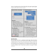
The GroundAware™ user interface is an extended instance of GoogleMaps and is very
intuitive to use by anyone who has experience with web-based mapping web sites. The
traditional controls for zoom, pan, etc. work the same as with a standard GoogleMaps
Section
T