
User's Manual
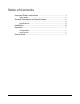
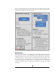
Table Of Contents
- Safe Usage
- General Description and Specifications
- Installation
- Operation
- User’s Guide
- The GroundAware™ user interface is an extended instance of GoogleMaps and is very intuitive to use by anyone who has experience with web-based mapping web sites. The traditional controls for zoom, pan, etc. work the same as with a standard GoogleMaps...

4
Figure 2-1 below illustrates how the GroundAware™ system and sub-systems interact
and what is typically provided by Dynetics and by the user/reseller. NOTE: Optional
integrated cameras and other sensors not shown.
FIGURE 2-1 GroundAware™ System/Sub-System Block Diagram
Specifications
The GroundAware™ system is a sophisticated, multi-channel digital beam-forming
device that utilizes state of the art Direct Digital Synthesis (DDS) waveform generation
and digital signal processing to detect and very accurately track small, slow targets while
minimizing false alarms. The GroundAware™ design has been refined by Dynetics and
end user testing across the United States at various critical infrastructure facilities, and
each unit is integration tested before delivery and verified to meet the specifications
enumerated in Table 2-2 below. NOTE: These specifications only apply to the Radar
Sub-System.