
User Manual


12
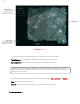
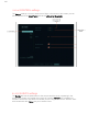
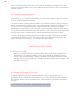
hold a finger on the map. A shaded circle will appear inside the red circle (Figure c). This
shaded circle shows four icons in order from the left, they are Mission, Survey, Land and
Loiter. When you press any of these icons, the shaded circle will vanish from the screen, and
you will use the function, confirming it with a second tap, and the shaded circle will reappear
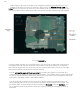
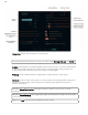
First, tap SURVEY->
A survey pattern will pop up on the iPad screen. Use your finger to adjust the survey grid for
coverage of areas on the map. Note that in the center of the survey pattern in an indicator
that tells how large the survey areas are. Use your finger to adjust the survey area. The flight
planner automatically calculates the shortest distance.
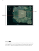
You can change the angle of the survey pattern by holding two fingers on the screen and
turning the survey pattern to adjust for windy conditions. If the pattern does not need adjustment,
remove your fingers and tap some empty area on the map. The mission will appear as Survey01
on the left of the tablet screen, under Slide to takeoff.
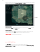
You can easily add a second mission to the first. Tap the screen and choose Survey. The
survey grid will pop up and you can choose and define a second area to be surveyed. Tap
the screen again, and the second survey will appear as Survey02 just under Survey01. You
can change the order of the missions with your finger by holding and dragging mission up
and down.