
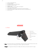
User Manual

10
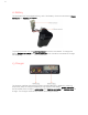
o Joystick Gyro: A small button next to the top of “Pitch and Yaw Joystick” joystick
activates the gyro in the iPad, and allows you to manipulate the plane by moving
your iPad up and down, left and right. Hold the iPad in your hands to manipulate it,
and press your thumb on the joystick. Removing your thumb deactivates the
joystick.
o Throttle: The joystick on the left of your screen is the throttle control, and allows you
to increase or decrease the plane’s altitude.
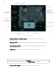
The map in the center of your screen is easily manipulated by sliding your finger. The
cross in the small black square is the geographical position of the pilot. Note the two
buttons in the upper left of the map.
o User Location:
The white circle centralizes (puts it in the center of the map) the pilot
location on the map.
o Drone Location:
The aircraft sign centralizes the position of the aircraft.
Located in the upper right of the map are three indicators
.
o Data Link:
this indicator shows you the strength of the data link.
o Battery:
this indicator indicates the battery level of the drone.
o HUB:
The bottom of the three indicates the battery level of the HUB (ground access
point)
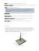
2.1.1 MISSION Tab
The MISSION tab is second of the five tabs you see on your iPad screen. It is
designed specifically for survey missions. Note that by using a finger you can move
the map. Note the red circle. The drone cannot pass outside this circle. It is called a
geofence, and is controlled from the SETTINGS tab. The geofence helps the pilot
follow the restricted space regulations that exist in some countries