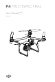
MULTISPECTRAL User Manual 2020.08 v1.
Searching for Keywords Search for keywords such as “battery” and “install” to find a topic. If you are using Adobe Acrobat Reader to read this document, press Ctrl+F on Windows or Command+F on Mac to begin a search. Navigating to a Topic View a complete list of topics in the table of contents. Click on a topic to navigate to that section. Printing this Document This document supports high resolution printing.
Using This Manual Legend Warning Important Hints and Tips Reference Before Flight The following documents have been produced to help you safely operate and make full use of your aircraft: 1. In the Box 2. User Manual 3. Quick Start Guide 4. Disclaimer and Safety Guidelines It is recommended to watch all tutorial videos on the official DJITM website and read the disclaimer and safety guidelines before first time use. Prepare for your first flight by reviewing the quick start guide.
Contents Using This Manual 2 Legend 2 Before Flight 2 Video Tutorials 2 Download DJI GS Pro App 2 Download DJI Terra 2 Product Profile 6 Introduction 6 Feature Highlights 6 Preparing the Aircraft 7 Activating the Aircraft 8 Aircraft Overview 9 Remote Controller Overview 10 Aircraft 12 Profile 12 Flight Modes 12 Aircraft Status Indicators 13 Return to Home (RTH) 14 Aerial Photography Missions 18 RTK Functions 20 Vision System and Infrared Sensing System 20 Flight Rec
Flight Flight Environment Requirements 41 GEO (Geospatial Environment Online) System 41 Flight Restrictions 42 GEO Unlocking 43 Preflight Checklist 44 Calibrating the Compass 44 Starting/Stopping the Motors 45 Stopping Motors Mid-flight 46 Flight Test 46 DJI Assistant 2 for Phantom 49 Installation and Launching 49 Using DJI Assistant 2 for Phantom 49 Appendix Specifications 4 41 © 2020 DJI All Rights Reserved.
Product Profile This section introduces the P4 Multispectral and lists the components of the aircraft and remote controller. © 2020 DJI All Rights Reserved.
Product Profile Introduction The P4 Multispectral is a high-precision drone capable of multispectral imaging functions. The imaging system contains six cameras with 1/2.9-inch CMOS sensors, capable of capturing both color and narrow band images. The OCUSYNCTM HD image transmission built into both the aircraft and remote controller ensures stable transmission.
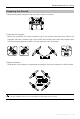
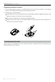
P4 Multispectral User Manual Preparing the Aircraft 1. Remove the gimbal clamp from the camera as shown in the figure. 2. Attaching the Propellers Mount the propellers with black propeller rings to the motors with black dots. Mount the propellers with sliver propeller rings to the motors without black dots. Press the propeller down onto the mounting plate and rotate in the lock direction until it is secured. 3.
P4 Multispectral User Manual Preparing the Remote Controller 1. Tilt the mobile device holder or the display device on the remote controller to the desired position, then adjust the antennas so they are facing outward. 2. Connecting your mobile device 1 Press the button on the top right side of the mobile device holder to release the clamp, then adjust the clamp to fit the size of your mobile device. 2 Secure your mobile device in the clamp by pressing down.
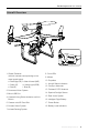
P4 Multispectral User Manual Aircraft Overview 10 9 14 8 13 7 6 5 4 11 3 2 a 12 b c 1 f d e 18 15 1. Gimbal Cameras (with six cameras corresponding to the wave bands below) a. Red Edge (RE) b. Near-Infrared (NIR) c. Green (G) d. Visible Light (RGB) e. Red (R) f. Blue (B) 16 8. Front LEDs 9. Motors 10. Propellers 11. Aircraft Status Indicators 12. OcuSync Antennas 2. Downward Vision System 13. Onboard D-RTK Antenna 3. Micro USB Port 14. Spectral Sunlight Sensor 4.
P4 Multispectral User Manual Remote Controller Overview 7 8 9 3 1 17 17 19 4 2 10 5 6 1. Power Button Used to turn the remote controller on and off. 2. Return to Home (RTH) Button Press and hold this button to initiate RTH. 3. Control Sticks Controls aircraft movement. Can be set to Mode 1, Mode 2, or Mode 3. 4. Status LED Indicates whether the remote controller is linked to the aircraft. 5. Battery Level LEDs Displays the battery level of the remote controller. 6.
Aircraft This section introduces the aircraft components, features and functions. © 2020 DJI All Rights Reserved.
Aircraft Profile The P4 Multispectral aircraft includes a flight controller, a communication system, a positioning system, a propulsion system and an Intelligent Flight Battery. This section describes the functions of these components. Flight Modes The P4 Multispectral provides the following flight modes. Use the flight mode switch on the remote controller to switch between different flight modes. The P and S positions on the remote controller are for P-mode, and the A position is for A-mode.
P4 Multispectral User Manual Aircraft Status Indicators The P4 Multispectral has Front LEDs and Aircraft Status Indicators. The positions of these LEDs are shown in the figure below: Aircraft Status Indicators Front LEDs The Front LEDs show the orientation of the aircraft. The Front LEDs glow solid red when the aircraft is turned on to indicate the front (or nose) of the aircraft. The Aircraft Status Indicators communicate the system status of the flight controller.
P4 Multispectral User Manual Return to Home (RTH) Return to Home (RTH) function brings the aircraft back to the last recorded Home Point. There are three types of RTH: Smart RTH, Low Battery RTH, and Failsafe RTH. This section describes these three scenarios in detail. Description GNSS If a strong GNSS signal was acquired before takeoff, the Home Point is the Home Point location from which the aircraft launched.
P4 Multispectral User Manual Low Battery RTH The low battery level failsafe is triggered when the DJI Intelligent Flight Battery is depleted to a point that may affect the safe return of the aircraft. The user can cancel the RTH procedure by pressing the RTH button on the remote controller. The thresholds for these warnings are automatically determined based on the aircraft’s current altitude and distance from the Home Point. The Low Battery RTH will only be triggered once during the same flight.
P4 Multispectral User Manual When the Critical low battery level warning is triggered and the aircraft begins to land automatically, push the left stick upward to make the aircraft hover at its current altitude, giving you an opportunity to navigate to a more appropriate landing location. The colored zones and markers on the battery level indicator bar reflect the estimated remaining flight time. They are automatically adjusted according to the aircraft’s current location and status.
P4 Multispectral User Manual Aircraft cannot return to the Home Point when GNSS signal is weak ([ ] displays grey) or the module is unavailable. If you move the throttle stick after the aircraft rises above 65 feet (20 meters) but below the pre-set Failsafe RTH altitude, the aircraft will stop ascending and immediately return to the Home Point.
P4 Multispectral User Manual decreases to 0% will the aircraft land. Users retain control of aircraft flight orientation. 3. If Landing Protection is inactive, DJI GS Pro will display a landing prompt when the aircraft descends below 0.3 meters. Tap to confirm or pull down the control stick for 2 seconds to land when the environment is appropriate for landing.
P4 Multispectral User Manual In , set the capture mode, bands to be stored, display mode, and color map. Capture mode: Select between single shot and timed shot. The minimum time interval of timed shot can be set to 1 s. When the time interval is set to 1 s, a microSD card with a write speed of at least 50 MB/s is required, such as the microSD card that comes with the aircraft.
P4 Multispectral User Manual RTK Functions The P4 Multispectral has a built-in DJI Onboard D-RTK, which provides more accurate data for centimeter-level positioning to improve operation precision when using with the DJI D-RTK 2 High Precision GNSS Mobile Station or Network RTK service.
P4 Multispectral User Manual The Infrared Sensing System consists [5] of two 3D infrared modules on both sides of the aircraft. These scan for obstacles on both sides of the aircraft and is active in certain flight modes. [5] [1] [2] [3] [4] Detection Range The detection range of the Vision System and Infrared Sensing System are depicted as follow. Note that the aircraft cannot sense and avoid the obstacles that are not within the detection range. 0.7m 13.1cm 6.8m 7m 6.8m 7m 0.
P4 Multispectral User Manual Using the sensors that are built into the Vision System, the aircraft can hover precisely even without GNSS. The Downward Vision System works best when the aircraft is at altitudes of under 33 ft (10 m). Operate the aircraft with great caution when flying at high speeds at low altitudes (under 0.5 m). Follow the steps below to use Vision Positioning: 1. Turn on the aircraft.
P4 Multispectral User Manual k) Flying over inclined surfaces that will deflect sound waves away from the aircraft. l) Flying over obstacles with too small effective infrared reflective surface. m) DO NOT position the sides of two aircraft toward each other to avoid interference between the 3D infrared modules. n) DO NOT cover the protective glass of the infrared module. Keep it clean and undamaged. o) Flying at high speed at low altitude (under 0.5 m). Keep sensors clean at all times.
P4 Multispectral User Manual Detaching the Propellers Press the propellers down into the motor mount and rotate in the unlock direction. Be aware of the sharp edges of the propellers. Handle with care. Use only the DJI approved propellers. Do not mix propeller types. Check that the propellers and motors are installed correctly and firmly before every flight. Ensure that all propellers are in good condition before each flight. DO NOT use aged, chipped, or broken propellers.
P4 Multispectral User Manual 8. Short Circuit Protection: Automatically cuts the power supply when a short circuit is detected. 9. Battery Cell Damage Protection: DJI GS Pro displays a warning message when a damaged battery cell is detected. 10. Sleep Mode: To save power, the battery enter sleep mode after 20 minutes of inactivity. 11. Communication: Information pertaining to the battery’s voltage, capacity, current, etc. is transmitted to the aircraft’s main controller.
P4 Multispectral User Manual Checking the Battery Level The Battery Level Indicators display how much power remains. When the battery is turned off, press the Power Button once. The Battery Level Indicators will light up to display the current battery level. See below for details. The Battery Level Indicators will also show the current battery level during charging and discharging. The indicators are defined below. : LED is on. : LED is flashing. : LED is off.
P4 Multispectral User Manual Battery Level Indicators While Charging LED1 LED2 LED3 LED4 Battery Level 0%~25% 25%~50% 50%~75% 75%~100% Fully Charged Using the Power Adapter and Charging Hub for Charging 1. Connecting to a Power Source Connect the power adapter to a power outlet (100-240V, 50/60Hz), then connect the charging bub to the power adapter. AC Power Adapter Power Outle Charging Hub 2.
P4 Multispectral User Manual Be sure to align the grooves on the Intelligent Flight Battery with the battery slot tracks. The Status LED Indicator will turn solid yellow if the battery is properly inserted. In storage mode, you can power on the Intelligent Flight Batteries to discharge them without having to connect to a power source if all batteries have more than 50% power. Status LED Indicator Description Status LED Indicator Description Charging Mode — Solid Yellow Queuing to charge ......
P4 Multispectral User Manual DJI does not take any responsibility for damage caused by third-party chargers. If the battery level is above 95%, turn on the battery before charging. How to discharge your Intelligent Flight Battery: Place the Intelligent Flight Battery into the battery compartment and turn it on. Fly the aircraft out doors until the battery level is low (such as 20% of power left). © 2020 DJI All Rights Reserved.
Gimbal Cameras This section provides the technical specifications of the cameras and explains the gimbal operation. 30 © 2020 DJI All Rights Reserved.
Gimbal Cameras Cameras Profile The P4 Multispectral imaging system contains six cameras with 1/2.9-inch CMOS sensors, including an RGB camera that produces images in the JPEG format and a multispectral camera array containing five cameras that produce multispectral images in the TIFF format. It uses a global shutter to ensure performance.
P4 Multispectral User Manual Camera Operation Use the shutter and video recording buttons on the remote controller or in DJI GS Pro to shoot the photos or videos. Gimbal Profile The 3-axis gimbal provides a steady platform for the attached camera, allowing you to capture clear, stable images and video. Turn the dial to adjust the gimbal pitch angle. The controllable range of the pitch angle is -90° to +30°.
Remote Controller This section describes the features of the remote controller and includes instructions for controlling the aircraft and cameras. © 2020 DJI All Rights Reserved.
Remote Controller Profile The remote controller features DJI’s long-range transmission technology OcuSync that is capable of controlling the aircraft and the gimbal cameras at a maximum transmission range of 4.3 mi (7 km). Connect an iPad to the remote controller via the USB port to use DJI GS Pro app to plan and perform missions. Export the captured images for analysis and create multispectral maps. Compliance Version: The remote controller is compliant with local compliance and regulations.
P4 Multispectral User Manual Charging the Remote Controller Charge the remote controller using the included charger. Refer to the figure below for more details. Power Outlet Charger Controlling the Camera Shoot videos/photos, and adjust gimbal pitch angle via the Shutter Button, Video Recording Button, and Gimbal Dial on the remote controller. 1 2 3 1. Gimbal Dial Control the tilt of the gimbal. Turn left to tilt the gimbal upward and right to tilt the gimbal downward. 2.
P4 Multispectral User Manual Controlling the Aircraft This section explains how to control the orientation of the aircraft through the remote controller. Control can be set to Mode 1 , Mode 2 or Mode 3, or to a custom mode.
P4 Multispectral User Manual Remote Controller (Mode 2) ( Aircraft Indicates Nose Direction) Remarks Moving the left stick up and down changes the aircraft’s elevation. Push the stick up to ascend and down to descend. When both sticks are centered, the P4 Multispectral will hover in place. The more the stick is pushed away from the center position, the faster the P4 Multispectral will change elevation. Always push the stick gently to prevent sudden and unexpected elevation changes.
P4 Multispectral User Manual Flight Mode Switch Toggle the switch to select the desired flight mode. Choose between P-mode and A-mode. Position Figure Position 1 Flight Mode Position 1 P-mode Position 2 P-mode Position 3 A-mode Position 2 Position 3 RTH Button Press and hold the RTH button to start the Return to Home (RTH) procedure. The LED ring around the RTH Button will blink white to indicate that the aircraft is entering RTH mode.
P4 Multispectral User Manual Remote Controller Status LED The Status LED reflects the strength of the connection between the remote controller and the aircraft. The RTH LED indicates the RTH status of the aircraft. The table below contains more information about these indicators. RTH LED Status LED Status LED Alarm — Solid Red Chime — Solid Green Chime Slow Blinking Red D-D-D...... Remote Controller Status The remote controller is disconnected from the aircraft.
Flight This section describes safe flight practices and flight restrictions. 40 © 2020 DJI All Rights Reserved.
Flight Once the pre-flight preparation is complete, it is recommended to hone your flight skills through training and practice flying safely. The altitude limit is 1, 640 feet (500 meters). Avoid flying at any altitudes higher. It is important to understand basic flight guidelines for the safety of both you and those around you. Refer to the disclaimer and safety guidelines for more information. Flight Environment Requirements 1. Do not use the aircraft in severe weather conditions.
P4 Multispectral User Manual Warning Zones, Enhanced Warning Zones, Authorization Zones, Altitude Zones, and Restricted Zones. By default, GEO limits flights into or taking off within zones that may result in safety or security concerns. There is a GEO Zone Map, which contains comprehensive global GEO Zone information on the official DJI website: https://www.dji.com/flysafe. The GEO System is for advisory purposes only.
P4 Multispectral User Manual GEO Zone Flight Restrictions GEO Zone Description Takeoff: The aircraft’s motors cannot be started. Restricted Zone In-flight: When GNSS signal changes from weak to strong, DJI GS RTK starts a 20-second countdown. Once the countdown is over, the aircraft immediately lands in semi-automatic descent mode and turns off its motors after landing. In-flight: When the aircraft approaches the boundary of the Restricted Zone, it automatically decelerates and hovers.
P4 Multispectral User Manual Zone and other requirements. It is available in all countries and can be applied for on the website: https://www.dji.com/flysafe. For more information about unlocking, please visit https://www.dji.com/flysafe or contact flysafe@ dji.com. Preflight Checklist 1. Remote controller, Intelligent Flight Battery are fully charged. 2. Propellers are mounted correctly and firmly. 3. MicroSD card has been inserted. 4. Gimbal and camera are functioning normally. 5.
P4 Multispectral User Manual 4. Re-calibrate the aircraft if the aircraft status indicators glows blinking red. If the Aircraft Status Indicator blinks red and yellow after the calibration procedure, move your aircraft to a different location and try again. DO NOT calibrate the compass near metal objects such as a metal bridge, cars, scaffolding.
P4 Multispectral User Manual OR Method 1 Method 2 Stopping Motors Mid-flight Perform the CSC to stop the motors. It can be enabled in the app. Go to Camera View, tap , Aircraft Settings, , then tap Advanced Settings to enable Stop Motors in Urgency. Only stop motors mid-flight in emergency situations when doing so can reduce the risk of damage or injury. OR Flight Test Takeoff/Landing Procedures 1. Place the aircraft in an open, flat area with the battery level indicators facing towards you. 2.
P4 Multispectral User Manual Video Suggestions and Tips 1. Go through the full pre-flight checklist before each flight. 2. Only shoot photos or record videos when flying in P-mode. 3. Always fly in good weather conditions and avoid flying in rain or heavy wind. 4. Choose the camera settings that suit your needs. Settings include ISO, exposure values, etc. 5. Perform flight tests to establish flight routes and preview scenes. 6.
DJI Assistant 2 for Phantom This section introduces the usage of the DJI Assistant 2 for Phantom software. 48 © 2020 DJI All Rights Reserved.
DJI Assistant 2 for Phantom Update firmware, copy flight records and calibrate the Vision System in the DJI Assistant 2 for Phantom software. For users that own DJI Agras aircraft, the DJI Assistant 2 for MG can also be used for the functions above. Installation and Launching 1. Download the software installation file from the P4 Multispectral download page: https://www.dji.com/p4-multispectral/downloads 2. Install the software. 3. Launch DJI Assistant 2 for Phantom.
Appendix 50 © 2020 DJI All Rights Reserved.
Appendix Specifications Aircraft Takeoff Weight 1487 g Diagonal Distance (Propellers Excluded) 350 mm Max Service Ceiling Above Sea Level 19685 ft (6000 m) Max Ascent Speed 6 m/s (automatic flight); 5 m/s (manual control) Max Descent Speed 3 m/s Max Speed 31 mph (50 kph) (P-mode); 36 mph (58 kph) (A-mode) Max Flight Time Approx. 27 minutes Operating Temperature 0° to 40° C (32° to 104° F) Operating Frequency 2.4000 GHz to 2.4835 GHz (Europe, Japan, Korea) 5.725 GHz to 5.
P4 Multispectral User Manual Rate of Data Collection Max operating area of approx. 0.63 km2 for a single flight at an altitude of 180 m, i.e., GSD is approx. 9.52 cm/pixel, with a forward overlap rate of 80% and a side overlap ratio of 60%, during a flight that drains the battery from 100% to 30%. Gimbal Controllable Range Vision System Pitch: -90° to +30° Velocity Range ≤ 31 mph (50 kph) at 6.
P4 Multispectral User Manual Remote Controller Operating Frequency 2.4000 GHz to 2.4835 GHz (Europe, Japan, Korea) 5.725 GHz to 5.850 GHz (Other countries/regions)[1] Built-in Battery 2.4 GHz: < 20 dBm (CE / MIC / KCC) 5.8 GHz: < 26 dBm (FCC / SRRC / NCC) FCC / NCC: 4.3 mi (7 km); CE / MIC / KCC / SRRC: 3.1 mi (5 km) (Unobstructed, free of interference) 6000 mAh LiPo 2S Operating Current / Voltage 1.2 A @ 7.
DJI Support http://www.dji.com/support This content is subject to change. Download the latest version from https://www.dji.com/p4-multispectral If you have any questions about this document, please contact DJI by sending a message to DocSupport@dji.com. DJI is a trademark of DJI. Copyright © 2020 DJI All Rights Reserved.