
User manual


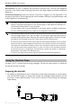
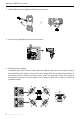
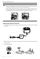
Table Of Contents

DJI Mavic 3E/3T User Manual
7
©
2022 DJI All Rights Reserved.
• The major difference between the DJI Mavic 3E and DJI Mavic 3T is the gimbal and
camera. The general descriptions in this manual apply to both Mavic 3E and Mavic 3T.
The illustration takes Mavic 3T as an example.
• For more details, refer to the DJI FlightHub 2 User Guide, which is available to download
from the official DJI website https://www.dji.com/flighthub-2/downloads.
• The maximum flight time was tested in an environment without wind while flying at a
consistent flight speed of 20.1 mph (32.4 kph). The maximum flight speed was tested at
sea level altitude without wind. Note that the maximum flight speed is limited to 42 mph
(68.4 kph) in the European Union (EU). These values are for reference only.
• The remote control devices reach their maximum transmission distance (FCC) in a wide-
open area with no electromagnetic interference at an altitude of about 120 m (400 ft).
The maximum transmission distance refers to the maximum distance that the aircraft
can still send and receive transmissions. It does not refer to the maximum distance
the aircraft can fly in a single flight. The maximum runtime was tested in a laboratory
environment. This value is for reference only.
• 5.8 GHz is not supported in certain regions. Observe local laws and regulations.
Using for the First Time
DJI Mavic 3E/3T is folded before being packaged. Follow the steps below to unfold the
aircraft and remote controller.
Preparing the Aircraft
1. All Intelligent Flight Batteries are in hibernation mode before shipment to ensure safety.
Use the provided charger to charge and activate the Intelligent Flight Batteries for the
first time. It takes approximately 1 hour and 20 minutes to fully charge an Intelligent
Flight Battery.
AR Projection: DJI Pilot 2 supports the projection of Home Point, PinPoint, and Waypoint
locations in the camera view, providing users with clear flight targets and better situational
awareness.
Cloud-based Mapping: when the remote controller is logged in to DJI FlightHub 2, the
aircraft can perform a cloud mapping task, which enables viewing of and generating a map
on DJI FlightHub 2 simultaneously.