
Manual

DJI Air 3
User Manual
©
2023 DJI All Rights Reserved.
111
GEO Awareness
GEO Awareness contains the features listed below.
UGZ (Unmanned Geographical Zone) Data update: user can update the y safe data through
GPS by using the data update feature and store the data in the aircraft.
GEO Awareness Map Drawing: after the latest UGZ data is updated, a flight map with a
restricted zone will be displayed in the DJI Fly app. Name, eective time, height limit, etc., can be
viewed by tapping the area.
GEO Awareness Pre-Warning: the app will prompt the user with warning information when the
aircraft is near or in a restricted area, the horizontal distance is less than 160 m, or the vertical
distance is less than 40 m from the zone to remind the user to y with caution.
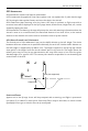
AGL (Above Ground Level) Statement
The vertical part of ‘‘Geo-awareness’’ may use the AMSL altitude or the AGL height. The choice
between these two references is specied individually for each UGZ. Neither AMSL altitude nor
the AGL height is supported by DJI Mavic 3 Pro. The height H appears in the DJI Fly app camera
view, which is the height from the aircraft takeo point to the aircraft. The height above the
takeoff point may be used as an approximation but may differ more or less from the given
altitude/height for a specic UGZ. The remote pilot remains responsible for not breaching the
vertical limits of the UGZ.
Restricted Zones
Appear red in the DJI app. Users will be prompted with a warning, and flight is prevented.
UA cannot y or takeo in these zones. Restricted Zones may be unlocked, to unlock contact
ysafe@dji.com or go to Unlock A Zone at dji.com/ysafe.
Takeoff
AGL (not supported)
H
Height error