
User Manual

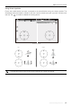

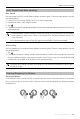
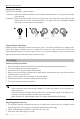
Table Of Contents
- Using This Manual
- Legend
- Read Before the First Flight
- Video Tutorials
- Download the DJI GO 4 App
- Download DJI Assistant 2
- Product Profile
- Introduction
- Feature Highlights
- Preparing the Mavic Air
- Aircraft Diagram
- Remote Controller Diagram
- Activation
- Aircraft
- Flight Modes
- Aircraft LEDs and Status Indicator
- Return to Home
- Vision Systems
- Intelligent Flight Modes
- Advanced Pilot Assistance Systems
- Flight Recorder
- Attaching and Detaching the Propellers
- Intelligent Flight Battery
- Gimbal and Camera
- Remote Controller
- Using the Remote Controller
- Optimal Transmission Zone
- Linking the Remote Controller
- DJI GO 4 App
- Equipment
- Editor
- SkyPixel
- Me
- Controlling the Aircraft with a Mobile Device
- Flight
- Flight Environment Requirements
- Flight Limits and GEO Zones
- Preflight Checklist
- Auto Takeoff and Auto Landing
- Starting/Stopping the Motors
- Test Flight
- Appendix
- Specifications
- Calibrating the Compass
- Firmware Updates
- After-Sales Information

©
2018 DJI All Rights Reserved.
47
Flight
Once pre-ight preparation is complete, it is recommended that you use the ight simulator in the DJI
GO 4 app to hone your ight skills and practice ying safely. Ensure that all ights are carried out in an
open area. Refer to the Remote Controller and DJI GO 4 App sections for information about using the
remote controller and the app to control the aircraft.
Flight Environment Requirements
1. Do not use the aircraft in severe weather conditions. These include wind speeds exceeding 10 m/s,
snow, rain, and fog.
2. Fly in open areas. Tall structures and large metal structures may aect the accuracy of the on-board
compass and GPS system.
3. Avoid obstacles, crowds, high voltage power lines, trees, and bodies of water.
4. Minimize interference by avoiding areas with high levels of electromagnetism such as locations near
power lines, base stations, electrical substations, and broadcasting towers.
5. Aircraft and battery performance is subject to environmental factors such as air density and
temperature. Be very careful when ying 16404 ft (5000 m) or more above sea level, since battery
and aircraft performance may be reduced.
6. The Mavic Air cannot use GPS within the polar areas. Use the Downward Vision System when ying
in such locations.
Flight Limits and GEO Zones
Abide by all laws and regulations when ying your Mavic Air. Flight limitations are applied by default
in order to help users operate this product safely and legally. Flight limitations include altitude limits,
distance limits, and GEO Zones.
When operating in P-mode, altitude limits, distance limits, and GEO Zones function concurrently to
manage ight safety.
Flight Altitude and Distance Limits
The ight altitude and distance limits may be changed in the DJI GO 4 app. The maximum ight altitude
setting cannot exceed 1640 ft (500 m). Based on these settings, your Mavic Air will y in a restricted
cylinder, as shown below:
Max Flight Altitude
Max Radius
Home Point
Height of aircraft
when turned on