
User's Manual
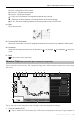
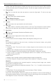

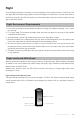
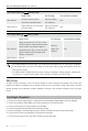


Table Of Contents
- Using This Manual
- Product Profile
- Aircraft
- Flight Modes
- Aircraft LEDs and Status Indicator
- Return to Home
- Vision Systems and Infrared Sensing Systems
- Advanced Pilot Assistance Systems (Only Mavic 2 Enterprise is supported)
- Flight Recorder
- Password Protection
- Attaching and Detaching the Propellers
- Intelligent Flight Battery
- Gimbal and Camera
- DJI AirSense
- Modular Accessories
- Remote Controller
- DJI Pilot App
- Flight
- Appendix

Mavic 2 Enterprise Series User Manual
©
2019 DJI All Rights Reserved.
51
H 10.0 m
: Height from the Home Point.
HS 10.0 m/s
: Aircraft horizontal speed.
VS 2.0 m/s
: Aircraft vertical speed.
113.95, 22.54
Coordinate: The longitude and latitude of the aircraft.
: Shows the remaining capacity or recording duration of the internal storage.
12
:
45
: Shows the remaining capacity or recording duration of the microSD card.
24. Map
Tap to view the map.
25. Time and GPS Information
Shows the current date, time and the longitude and latitude of the aircraft. Only available in Visible mode.
26. Accessory
Shows the connecting accessory such as the beacon , the spotlight or the speaker ; tap to use
or set.
27. Back
: Tap to return to the main menu.
Mission Flight
(Only DJI Pilot App on Android is supported)
Tap to enter the mission library. Set a waypoint ight path, dene waypoint actions then start ying
with a tap.
19:29
In Flight (GPS)
74%
70%
4.07V
4.07V
1243 m
4 m 17 s
8
0
Task1
Waypoints
Speed
Height
Drone Yaw
Route
5m /s
10m
Along the Route
Gimbal Control
Set Each Waypoint
Completion
Hover
S
E
Estimated TimeDistance Waypoints Photos
S
2
3
4
5
7
6
8
1
10
12
11
13
14
2 3 4 5 6 7 8 9
Tap on the map to add waypoints, then congure route and waypoints settings.
1. PointofInterest(POI)
: Tap to enable the POI function and a POI will be displayed on the map. Drag to adjust its