
Specifications


Interface with Google Earth
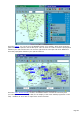
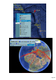
TRX-Manager provides an interface with Google Earth. The Google Earth application (V5 or
later) must be installed on your computer.
A google Earth icon appears in various modules : Logbook, CD-Rom (RAC, Buckmaster,
QRZ.COM), DX Cluster, Web Cluster, Quick Memories, SWL Database... Each time you press a
Google Earth icon, TRX-Manager creates a TRX.KML file and opens Google Earth. The display
depends on the context and may include a single station or paths to different stations. Zoom
level is adjusted according to the accuracy of available data. Location is calculated from
Long/Lat, Grid or DXCC Prefix): CD-Roms are the most accurate since they generally provide
Longitude and Latitude (at least for stations in NA) ; if longitude and latitude are not
available, the Google Earth icon stays grayed out.
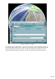
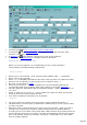
From the Logbook, TRX-Manager allows you to choose various options:
To display either the current station, the current QSOs selection (defined by the SELECT
function) or all the logbook,
For the current station, position can be extracted from DXCC Prefix, Grid, QTH or
Address (in case of you choose Address or QTH, you must edit the corresponding field
according the to the format required by Google Earth: standard street, city, state,
country),
The file name of the kml file.
Page 264