
Users Guide


Presentation Portlets and Editors | Presentation Capabilities
236 OMNM 6.5.3 User Guide
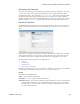
You can also enter the address in the Search field, or click and drag the marker that appears on this
screen. Click
Apply
to accept the re-location. A
Delete Tag
button appears when you have created a
tag, and lets you remove it.
Cancel
closes the screen.
NOTE:
You can zoom in or out on the displayed map with the + and - buttons in the upper left corner of this
screen.
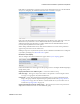
Map Context
In addition to displaying filtered-by-Hierarchical View portlets, you can view discovered devices in
the
Map Context
portlet, automatically placed by location.
Notice that you can move the center of the map with the arrows in its upper left corner above the
zoom in/out (+/-) buttons. The menu in the upper right corner lets you select a
Map
or
Satellite
views, and fine-tune them to include labels, terrain and so on.
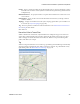
In addition to the
Help
and
Settings
icons at the top of this portlet, you can also
Toggle Marker
Style
(pushpins or triangles),
Toggle Marker Clustering
(combine markers into cluster marker when
they are near each other), or
Search by Name
for a location. Clustered markers display the number
of separate markers combined within them.
NOTE:
The Search function is case-sensitive. Omit the initial letter if you are uncertain about capitalization for a
tagged location.
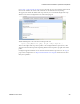
Clicking the
Settings
icon produces a screen where you can configure the default marker style,
whether clustering is enabled, and where you can save the current map boundaries (
Save Current
Bounds
), which appear, read-only, below that option.