
User manual

24 |
Instructions
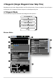
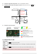
1) LOG to print info. Such as: upload success, upload failed…
2) Waypoint list: you can click the yellow icon to select the waypoint properties in the table.
3) You will see Mission properties if14) selected.
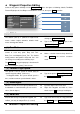
Mission properties
Mission Time Lmt: If the flight-time exceeds the value (>=60sec), it will automatically go
home.
Route: The selection of mission execution mode: includes both modes of Start_to_End and
Continuous.
StartWayPoint: Defines the first way point your aircraft goes to after you click GO. Select the
proper way point index number listed.
VerticalSpeedLimit: Vertical speed for up or down direction, Unit is m/s.
Set Mission properties
SetAllWPsAlt: Set altitude of all waypoints.
SetAllWPsSpeed: Set speed of all waypoints.
SetAllWPsTurnMode: Set turn mode of all waypoints: StopAndTurn, Bank_turn,
Adaptive_Bank_Turn and None。
SetAllAction: Setup the parameters of a set of repeat actions.
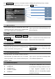
4) Description of selected item.
5) Altitude change 10m or 1m per click.
6) Add new way point by click +, and then click on the map. Or left click on the map with Ctrl. Delete
way point by selecting them, and then click -.You will delete the selected point.
7) Clear: if you want to delete running mission or editing mission in the map you can click the clear
button.
8) Save and Open the mission.
9) Cancel: All edited way points.
10) Upload the mission to Main Controller.
11) Click Go to Execute Assigned Mission, Including Auto Take off as assigned.
12) You will see Waypoint properties (if any items in (2) were selected) for Editing Mission is writeable;
Assigned Mission is read only.
Latitude & Longitude: Units are in degree.
Altitude: Unit is in meters.