
User's Manual


CSI-Wireless AssetLink 200 Installation and Operating Instructions
Revision 1.0 Page 5 1/2/2002
The GPS receiver can be configured during the Armed Mode to specify the
“maximum time to fix” interval allowed for the GPS receiver to get a fix before
powering off the GPS. This mode is necessary in situations where the GPS
antenna is completely hidden from the sky and cannot get an updated position fix
during its Armed Mode ‘wake-up/status check’ cycle.
During the Armed mode the GPS receiver is immediately powered off after
getting a valid fix and determining that the vehicle has not moved. However, the
cellular transceiver will remain on for the duration of the ‘wake-up/status check’
cycle to listen for messages from the NCC.
2.1.2 Geo-fences
At the time of the installation the AssetLink 200 may be factory programmed
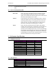
with 3 Geo-fences, and defaulted to the first 0-25 mile fence as follows:
1. ID # 1, 0 to 1 miles radius
2. ID # 2, 0 to 25 miles radius
3. ID # 3, 0 to 50 miles radius
Users can change these by contacting the NCC where commands can be sent to
the device to change the geo-fence. Alternatively they can execute these
commands via the web page interface. A geo-fence defines a boundary or a
geographic area calculated as a radius from a central point. Only one geo-fence
can be enabled at a time. The AssetLink 200 will send a Status message to the
NCC in the event that the vehicle crosses outside the fence selected.
Each Geo-fence is defined by the following parameters:
• ID (1-3) used to identify a particular constraint region. This value is created and
stored by the host, not by the AssetLink 200.
• Type (out of only)
• Boundary –- circle with radius. Center of circle is Home Origin.
• Trigger - The AssetLink 200 will generate an exception, when it has a valid GPS
fix, based on:
1. The vehicle crossing the geo-fence,
2. When the unit powers up outside a geo-fence.
2.1.3 Distance and Home Origin
One Latitude-Longitude position, referred to as Home Origin, can be kept in the
FCP EEPROM configuration memory. This data point is used to calculate the
radii of the selected geo-fence, and subsequently the distance from the center of
the circle. In the event that the vehicle exits this circle a trigger can be generated
and sent to the NCC.
2.2 System Timing
The AssetLink 200 maintains accurate system time necessary to support the
Armed Mode of operation. When the GPS receiver is active and can see at least
one GPS satellite the AssetLink 200 system time is synchronized to the GPS
time.