
Frequently Asked Questions
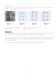
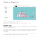
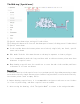
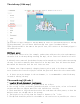
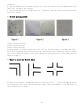
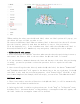
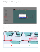
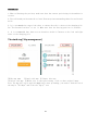
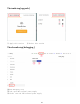
Table Of Contents

The sixth step [ Edit map ]
①Click Save to apply changes to the map   ② Clear all user modifications to the map
③ Drop-down menu, you can choose different map area types (introduced below)
④The operation mode is the same as the special area, the interior of the drawn polygon is
the modified area
Additional notes:
1. Blank area: remove noise (for example, pedestrians walk past the noise and temporary
obstacles left on the map during scanning the map), do not treat real obstacles as noise.
2. Obstacle area: some real fixed obstacles may not be scanned very clearly when constructing
the map. You need to manually draw obstacles on the map (note that the obstacles drawn
must match the obstacles that the real laser can scan
3. Unknown area: Some frequently changing feature points need to be drawn as unknown
areas (such as the flow area of people outside the glass wall where the robot cannot walk).
4. If there are major changes in the environment, it is recommended to rebuild the map
instead of editing the map.
The seventh step[ QR code ]
➤
Location QR code deployment requirements
1. The ceiling is parallel to the ground and do not reflect
2. The ceiling is flat, preferably painted with paint or latex paint, or has a flat metal
surface,and does not support materials with insufficient viscosity
3. There should be no large obstructions above the road where the robot passes, so that the
machine cannot see the QR code on the passage
4. The height of the ceiling from the camera is between 1.5 m ~ 2.3 m
5. The QR code should be pasted in the middle of the road as far as possible,not close to
14