
Operating instructions

M300USERSGUIDE SEA
DATADISPLAYS
189
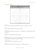
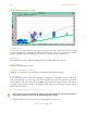
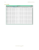
MOVINGAIRMASS(MAM.300)
Latitude
The aircraft’s angular distance north or south of the earth’s equator, measured in degrees.
Longitude
The aircraft’s angular distance on the earth's surface, measured east or west from the prime meridian
at Greenwich, England, measured in degrees.
Speed
The rate at which the aircraft is traveling during a moment in time.
SetPosition
This button will make the point the aircraft is currently at the point of origin for the plot.
Rings
Changing this value changes the number of reference rings displayed on the graph. With this
example plot, the value is five which is why 5 reference rings are displayed on this graph.
MaximumLimit
The value which restricts the maximum range of the plot.
Heading
The current direction the aircraft is following measured in degrees from the original graph starting
point.
Direction
The aircraft’s angular relationship, measured in degrees, to due north.
Aircraft
The pictorial representation of the aircraft.