
User's Guide


SinoGNSS
○
R
T300 PLUS User Guide
54
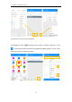
Choose the data that you want to export including survey point, input point, control point,
stake point, base, line and polygon, and the layer properties includes name, code and
height, the default text height is 0.5.
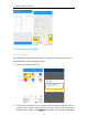
7.3 Import Basemap
Tap Basemap to import DXF/DWG/SHP file into Survey Master.
• Add points: Save points from the dxf/dwg/shp file to element.
• Add lines: Save lines from the dxf/dwg/shp file to element.
• Prefix: Support add prefix name for points/lines saved to Elements.
• Add line endpoints: add line endpoints to point element.