
User's Guide


SinoGNSS
○
R
T300 PLUS User Guide
53
7.2 Export
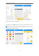
Tap Export in Project interface to export simple data of survey points. Also, click More
formats to export the survey points with detailed information or other formats like stake
points/lines, DXF, SHP, KML, RAW, RW5, HTML, CASS feature result.
Same with Import result, long press the predefined data format to select the interface you
want to place.
• File format: support *.csv, *.dat, *.txt format
Choose one format to export data.
• Select: support Survey point, Control point, Input point, Stake point, Base, also, you
can set the date, name, code of data to specific export
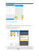
The default export path is …/Sinognss/sm/export, and the previous saved file will be shown
below, you can also click Upper folder to change to any other path.
For the points, lines and polygons you surveyed in Topo survey and Feature survey, you
can click Export DXF to export dxf file, then you can edit them in third party CAD software,
or import to Basemap to check, or import to Stake CAD to stake.