
User's Guide


SinoGNSS
○
R
T300 PLUS User Guide
51
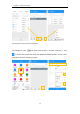
• Angular transformation: Angular type transform;
• Two points: Calculate two points distance;
• Point to line: Distance from point to one line;
• Offset point: Calculate point with azimuth and distance;
• Deflection angle: Calculate angle of two lines;
• Deflection point: Calculate point with angle and distance;
• Intersection point: Calculate intersection points from two lines;
• Bisection point: Calculate point from angle bisector;
• Points from line: Calculate points on line by distance or segment;
• Point average: Calculate average from points;
7 Data Export/Import
Survey Master supports to import/export data including grid coordinate, Lat/Lon
coordinate with various data format, support import DXF/DWG file and export result
of DXF/KML, etc.
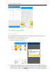
7.1 Import
Tap Import in project interface, there are some predefined data formats, click More
formats to get more predefined formats. Besides, you can click Add to create a User-
defined type.
Long press the predefined data format that you don’t use often, you can move this
format to the More formats page; also, you can move the data format of More formats
page to the previous page where stored the formats you usually use.