
User's Guide
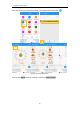
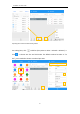
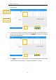
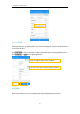
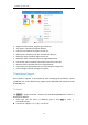
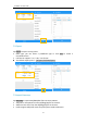
Table Of Contents

SinoGNSS
○
R
N5 User Guide
42
Angular transformation: Angular type transform;
Two points: Calculate two points distance;
Point to line: Distance from point to one line;
Offset point: Calculate point with azimuth and distance;
Deflection angle: Calculate angle of two lines;
Deflection point: Calculate point with angle and distance;
Intersection point: Calculate intersection points from two lines;
Bisection point: Calculate point from angle bisector;
Points from line: Calculate points on line by distance or segment;
Point average: Calculate average from points;
7 Data Export/Import
Survey Master supports to import/export data including grid coordinate, Lat/Lon
coordinate with various data format, support import DXF/DWG file and export result
of DXF/KML, etc.
7.1 Import
Tap Import in project interface ->Choose Grid Coordinate/WGS84/Local LanLon ->
Click Path to add files.
Data type: you can select a predefined type or click Add to create a
User-defined type.
File format: support *.csv, *.dat, *.txt format.