
User's Guide
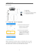
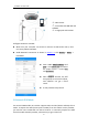
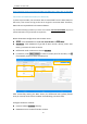
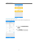
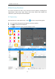
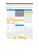
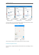
Table Of Contents

SinoGNSS
○
R
N5 User Guide
32
6.1.1 Survey settings
6.1.2 Bubble setting for Tilt survey
Bubble option will appear when receiver supports for tilt survey, it is available for
ComNav Technology N5 GNSS receiver, use IMU sensor.
According to the IMU sensor, can not only meets the requirement of high precision
measurement, but also relieves the users from continually checking whether the
pole is plumb. When the pole tilts within 60°, the built-in sensor based IMU
precisely calculates the actual offset, which accuracy can up to 2.5 cm
Fixed: only fixed result can be saved;
Duplicate name: allow point name same;
RMS: point accuracy need higher than
the value;
Offset radius: point cannot offset bigger
than the value during measure;
Occupation time: measure times for one
point;
Point stepsize: for point name;
Stake range: show circle when close to
target point;
Direction guide: 3 methods showing
guide for stake out;
Electronic compass: Use controller
compass during stake out;
Auto centered: Map will go to current
location after 5 seconds;
Keep centered: Map will go to current
location after 1 second;
Display survey points: will show all
survey points on map;
Display Basemap: for showing DXF/SHP
file on map