
Operator`s manual


1.3.4 Sky Map
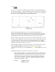
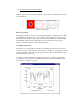
The most obvious feature of the SRT control panel window is the sky map (Figure-5).
The map shows full sky coverage in azimuth and elevation with 10-degree tick marks in
both axes. The azimuth axis is labeled every 20 degrees, the elevation every 10 degrees.
The elevation scale is exaggerated 33% from the azimuth scale.
(Figure-5, Sky Map)
Plotted automatically and labeled are the sources listed in the srt.cat file. Geo-
synchronous communications satellites in the catalog are indicated by blue dots. The
galactic equator is plotted. The north galactic pole and the 0, 90, 180 and 270 galactic
longitude quadrants are also plotted since they have been placed in the catalog.
The user can move the pointer to any plotted source and click on that source to select it
from the source list. When the source is selected, the source plot, label and the telescope
"crosshairs" will be colored red. Selecting a source in this manner does not initiate
telescope motion to the source however, only an additional action such as clicking the
track button will engage the telescope controls.
While the SRT is slewing, the right side information box below the map will carry the
message Status; slewing. The sky map will show the telescope "crosshairs"
superimposed on the selected source and illuminated yellow until the SRT arrives at the
source.
The SRT travel limits are also plotted as square boxes on the screen.
The azimuth travel limits are set in the srt.cat file. In the above illustration, the
limits are approximately 91 to 269 degrees. Coverage of the 271 to 89 degrees
azimuth is achieved by moving the elevation axis through the zenith to the
desired elevation and thus a "plus 180º " azimuth position. A total elevation
travel of up to 179 degrees is possible by setting the ELLIMIT command in
srt.cat allowing full sky coverage.
Example: AZLIMIT 20.0 359.0
ELLIMIT 2.0 90.0