
Owner's Manual


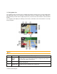
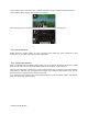

Table Of Contents
- Quick Start Guide & Installation Manual
- Table of Contents
- Parts & Controls
- Power On
- Main Menu
- DVD Video Player Operation
- CD Player Operation
- USB Audio Operation
- USB Video Operation
- iPod Operation
- Pandora Operation
- Bluetooth Audio Operation
- Bluetooth Phone Operation
- Tuner Operation
- SiriusXM Operation
- HDMI Mode
- Clarion Mobile Map
- Installation and Connections
- Owners Manual
- Navigation Manual
- Scan of CD-ROM
- Warranty

2.3 Navigation view
The navigation view is the main screen of NX405 that shows the planned route on a map. NX405 works
with digital maps which are not simply the computerized versions of traditional paper maps. Similarly to
paper road maps, the 2D mode of digital maps shows you streets and roads. Elevation is also illustrated
in color.
The navigation view displays the following screen buttons, data fields, and route information on the map
during navigation:
Note!
Some buttons, fields, or icons may not be available in your product version.
Number Name Description
1 Current
position
marker
The current position is displayed as a blue arrow by default. When there is
no GPS position, the current position marker is transparent and it shows
your last known position. See page 16.
2 GPS position
The dot near the arrow shows the GPS position as perceived by the GPS
receiver. See page 16.
3Planned route
The planned route is displayed as an orange line.
14 Clarion NX405 English