
User Manual

2/14/2018 Water Linked Underwater GPS Documentation
http://docs.bluerobotics.com/waterlinked/ 3/3
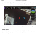
If everything is operating correctly, you should now find an ROV position on the map in
QGroundControl. The ROV position is indicated by a BlueROV image. The position of the surface vessel
or Water Linked Master Electronics box is indicated by a red arrow (not yet implemented). The small ‘H’
icon indicates the ‘home position’, the location of the ROV’s first GPS lock.
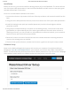
To configure the Water Linked Underwater GPS system, navigate to192.168.2.94/#/configurationin
your browser. Please refer to theWater Linked Underwater GPS User Manualfor further information
on configuration.
Software Update
Water Linked’s latest software revision is 1.2.1 (2 October 2017). The update file can be
downloadedhere. The update process is documented on page 17 of theUser Manual. The Underwater
GPS system displays its current software version at192.168.2.94/#/about.