
User's Manual Part 1

Release8PlanningGuide
Issue2,November2007 Draft5forRegulatoryReview 144
NOTE:
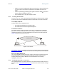
Visual line of sight does not guarantee radio line of sight.
12.6.1 ResourcesforMapsandTopographicImages
Mapping software is available from sources such as the following:
•
http://www.microsoft.com/streets/default.asp
• Microsoft Streets & Trips (with Pocket Streets)
•
http://www.delorme.com/software.htm
• DeLorme Street Atlas USA
• DeLorme Street Atlas USA Plus
• DeLorme Street Atlas Handheld
Topographic maps are available from sources such as the following:
•
http://www.delorme.com/software.htm
• DeLorme Topo USA
• DeLorme 3-D TopoQuads
•
http://www.usgstopomaps.com
• Timely Discount Topos, Inc. authorized maps
Topographic maps with waypoints are available from sources such as the following:
•
http://www.topografix.com
• TopoGrafix EasyGPS
• TopoGrafix Panterra
• TopoGrafix ExpertGPS
Topographic images are available from sources such as the following:
•
http://www.keyhole.com/body.php?h=products&t=keyholePro
• keyhole PRO
•
http://www.digitalglobe.com
• various imagery
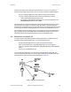
12.6.2 SurveyingSites
Factors to survey at potential sites include
• what pre-existing wireless equipment exists at the site. (Perform spectrum
analysis.)
• whether available mounting positions exist near the lowest elevation that satisfies
line of site, coverage, and other link criteria.
• whether you will always have the right to decide who climbs the tower to install
and maintain your equipment, and whether that person or company can climb at
any hour of any day.