
Specifications


5
1 General Scope of this Document
The Metrics for Ecosystem Services project examines the tradeoffs and synergies between
agricultural development, ecosystem services and livelihoods in large regions of Africa. These
areas are sometimes referred to as “African breadbaskets,” where a breadbasket is defined as: “A
region of high agricultural potential due to good rainfall, soils, infrastructure and markets, and
tended primarily by smallholder farmers” (Alliance for a Green Revolution in Africa; AGRA).
This protocol was designed to provide quantitative data on precipitation, temperature, relative
humidity and global solar radiation to support these types of tradeoff analyses. The protocol was
field tested in the Southern Highlands of Tanzania, an area comprising the five administrative
regions of Rukwa, Mbeya, Iringa, Morogoro and Ruvuma over a total area of 330,850 square
kilometers. Within the Southern Highlands, we implemented intensive monitoring in 20
landscapes, each covering an area of 100 km2 (10x10 km) and containing at least two
households whose agricultural plot boundaries were surveyed and digitized, and geo-referenced
as part of the annual Tanzania National Panel Survey (NPS) initiated in 2008/2009 in
collaboration with the World Bank.
Climate and particularly precipitation are key parameters for agricultural activities and
development. Ground-based measurements of climate parameters are comparatively sparse in the
tropics and only exist in isolation, i.e. spatially separated by large distances not allowing to
capture small to medium scale spatial variability in climate. This protocol describes the
installation and maintenance implementation of sophisticated climate stations meeting WMO
standards.
2 Methods
2.1 Overview
The goal of this protocol is to provide a standardized methodology to generate high-quality
reliable measurements of climatic variables in agricultural landscapes. This document describes a
ground-based protocol where all the instrumentation is installed on a tripod in an adequate-size
open area. This protocol implements measurements for four climatic variables: air temperature,
relative humidity, precipitation and global solar radiation. The sensors used, are mid-price
ranged, but sensitive and reliable enough to handle the rough conditions encountered in tropical
environments. The climate station operates automatically; the sensor data feeds into a data
logger, powered by a solar panel and a rechargeable battery (for night operation). The data logger
collects information from the sensors every 5 seconds and produces summaries every 5 minutes.
2.2 Personnel and Time Requirements
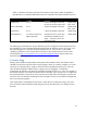
The personnel, qualifications and time necessary for installing the climate station are listed in
Table 1. Time estimates are for installation and one year of maintenance and include frequent
visits to the landscape for data collection and sensor maintenance. Travel times to and from the
landscape vary in each case and are not included here.