
Owner's manual


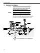

Table Of Contents
- Revision and Copyright Information
- Limited Warranty
- Assistance
- Table of Contents
- 1. Preparation and Siting
- 2. Hardware Installation
- 2.1 Base Foundation
- 2.2 Tower/Pole
- 2.3 Enclosure
- 2.4 Crossarm and Sensor Installation
- 2.5 Communication Peripherals
- 2.6 Lightning Rod Installation
- 2.7 Solar Panel Installation
- 2.8 Battery Installation
- 2.9 Restraining Cables and Sealing/Desiccating Enclosure
- 3. ET Software
- 4. Maintenance, Troubleshooting, and Schematics
- 4.1 Maintenance
- 4.2 Troubleshooting
- 4.2.1 No Response Using the CR1000KD Keypad
- 4.2.2 No Response from Datalogger through SC32B, RAD Modem, or Phone Modem
- 4.2.3 NAN or (INF Displayed in a Variable
- 4.2.4 Unreasonable Results Displayed in a Variable
- 4.2.5 NAN or (INF Stored in a Data Table
- 4.2.6 Communication Problems when using an RF450 Radio
- 4.2.7 Gill WindSonic1-ET Diagnostic Diagnostic Codes
- 4.3 Schematics of Connectors
- Appendix A. T107 Maintenance Log
- Appendix B. PS24 24 Ahr Power Supply and 10 x 12 inch Enclosure
- Appendix C. Exploded Views
- Appendix D. Default Programs
- Appendix E. Step-down Transformer Installation
- Campbell Scientific Companies
T107 Weather Station
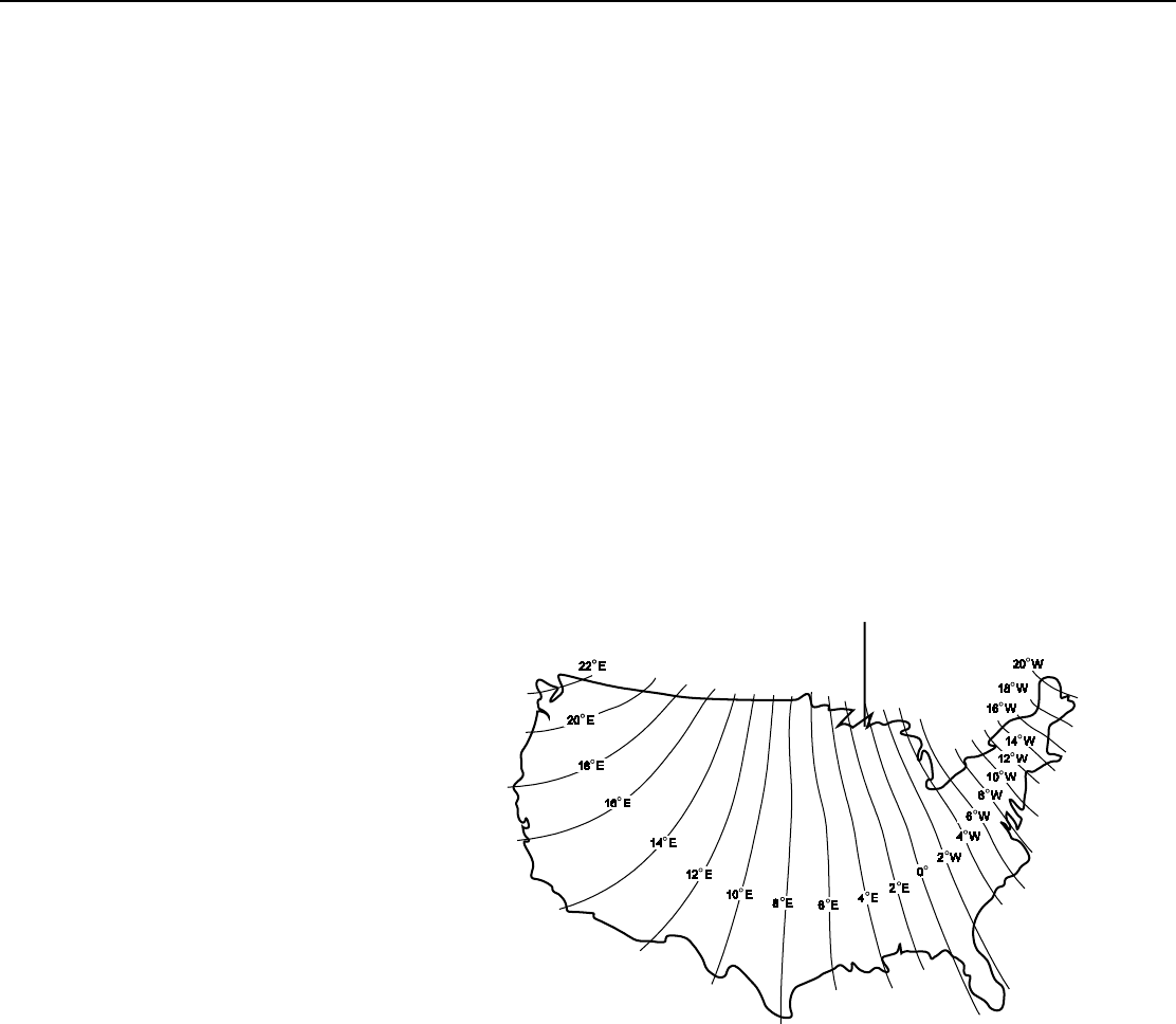
1.5 Determining True North for Wind Vane Orientation
Magnetic declination, or other methods to find True North, should be determined
prior to installing the weather station. True North is usually found by reading a
magnetic compass and applying the correction for magnetic declination*; where
magnetic declination is the number of degrees between True North and Magnetic
North. Magnetic declination for a specific site can be obtained from a USFA map,
local airport, or through a NOAA website (Section 1.5.1, Web Calculator). A
general map showing magnetic declination for the contiguous United States is
shown in FIGURE 1-6.
Declination angles east of True North are considered negative, and are subtracted
from 0 degrees to get True North as shown FIGURE 1-7. Declination angles west
of True North are considered positive, and are added to 0 degrees to get True
North as shown in FIGURE 1-8. For example, the declination for Logan, Utah is
12.4° East. True North is 360° - 12.4° = 347.6° as read on a compass.
* Other methods employ observations using the North Star or the sun, and
are discussed in the Quality Assurance Handbook for Air Pollution
Measurement Systems, Volume IV - Meteorological Measurements
4
.
Subtract declination from 360° Add declination to 0°
FIGURE 1-6. Magnetic Declination for the Contiguous United States
7