
Specifications


Map File Format
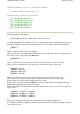
In the text below the lines in the map file are marked with a dot.
Only those parameters which can be modified/created by the user are described, parameters which
are used for special cases are not described.
The lines in green are optional
The Map File
The lines are in the order they are in the map file.
Header and Version of File
OziExplorer Map Data File Version 2.1
Title of Map -
any text string
Brisbane Region
Link to map image file
D:\OziMaps\regional\south.ozf2
Can be 1 of 2 things
1 TIFF scale factor
- redundant, no longer used and has been replaced by line below
1 ,Map Code,
- only used for special types of maps -
Note
-
cannot be modified by the user but
must be there.
Datum settings
WGS 84,, 0.0000, 0.0000,WGS 84 -
Note
-
for normal maps only the datum in the first field is
used the rest of the parameters are for datum shifts and there is normally no need for these to
be modified by the user.
Reserved fields, the lines must be there
Reserved 1
Reserved 2
Page
226
of
252
OziExplorer Help Contents